Mid-Continent

Valuable insights for the best subsurface understanding

Gloss Mountain and Canton

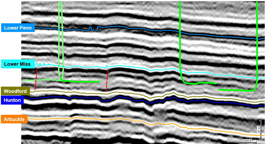
TGS has 11,990 square kilometers of data in the Mid-Continent region of the Lower 48 which includes the Gloss Mountain 3D survey with the nearby Canton 3D survey which together encompass approximately 2,895 square kilometers in Major, Woods and Blaine counties in the Anadarko Basin. Historical production in this area comes from stacked pay horizons ranging from the Ordovician Arbuckle to the Pennsylvanian Marmaton Group. Current targets include the Hunton, Woodford, and multiple zones within the Mississippian.

Gloss Mtn_Canton Image

TGS continues to upgrade technologies employed in AVO compliant processing such as low-frequency receiver correction, 5D interpolation, multi-dimensional/multi-pass noise attenuation, anisotropic migration, and quantitative QC’s (avo and well tie analysis, etc.). These technologies are critical for producing full integrity, high-resolution seismic products, fit-for-purpose for the generation of subsequent interpretive products.

Products for both 3D surveys are available immediately.

Kingberry 3D

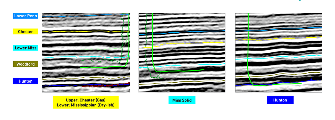
TGS Kingberry 3D encompasses 717 square kilometers in Kingfisher and Garfield counties in the Anadarko Basin of Oklahoma. The survey sits along the eastern flank of the Anadarko Basin along the Nemaha uplift and offers high resolution imaging of multiple productive Mississippian, Oswego and Hunton horizons. Seismic presents a high value in this part of the basin due to subtle erosion and subcropping of the reservoirs against the Nemaha high. Hunton reservoirs have historically been produced through conventional completions but are now being exploited by unconventional methods.

Kingberry Image


View more details in the TGS Data Library


Contact Us

Get in contact with our Onshore team to ask more about how we can help you with your subsurface intelligence needs.

  • Well-Intel-Logo-2020-FINAL

    Well Intel

    Onshore industry insights from the world's largest well performance data library

    Well Intel is our unique collection of insights, forecasts and expert analysis derived from the world's largest collection of well production and performance data. 

    These analyses seek to answer the questions on the minds of many of the region’s explorers using the largest data library in the world. Check back regularly for frequent updates or subscribe so you never miss an update.

    Visit Well Intel
  • landing-page-story-grid_story-banner_products-services_well-data_e-commerce-R360-2_1000x540

    R360

    Connect to the world’s largest and most complete well log database through an intuitive map-based interface.

    R360 seamlessly assimilates TGS data libraries with your existing technologies, giving you ready access to TGS Well Logs, Directional Surveys, Well Performance Data, Permits, Validated Well Headers, and Interpretation Products.

    Use R360 your way – through your desktop, laptop, tablet, or other mobile devices.

    Discover Now
  • Industry Updates Social Media

    Industry Updates

    TGS is excited to announce our brand-new daily newsletter to keep you informed with operator activity and breaking industry news articles. Everything you need for analyzing and planning, featuring competitive intel integrated with our GEONEWS article repository in one email notification.

    Subscribe to our daily e-newsletter to stay informed with competitive operator and drilling intel while featuring breaking industry news.

    Subscribe