

Basin in Focus: Kutei Basin
The Kutei Basin stretches from eastern Kalimantan into the deepwater Makassar Straits. It is Indonesia’s largest sedimentary basin and one of its most prolific petroleum provinces, it records a complex geological history of Eocene extension, post-rift subsidence, basin inversion, Mahakam Delta progradation, deepwater sedimentation and deformation associated with the West Sulawesi Fold Belt.
That history has created a diverse set of exploration opportunities in mature as well as frontier areas. Regional interpretation by TGS reconstructs depositional evolution from the Eocene to Early Pliocene, helping define sediment pathways, shelf development and deepwater connectivity. Potential play types extend from deeper syn-rift structures and carbonate build-ups on structural highs to deltaic traps, deepwater fans, contourites and lowstand sand systems. While parts of the basin are mature, the exploration story is far from complete. Deepwater areas in particular remain underexplored, creating a need to understand how proven petroleum system elements and reservoir fairways extend beyond established discoveries and existing well control.
Geliga-1 Discovery Sharpens the Exploration Picture
Against that geological backdrop, Eni’s recent Geliga-1 gas and condensate discovery provides another important exploration signal. It follows other successes in the basin, including Konta-1, Geng North-1, Gehem and Gendalo-Gandang, reinforcing the continuing prospectivity of a basin with a long production and exploration history.
The significance for explorers goes beyond a single well result. Each discovery adds another calibration point for understanding where effective reservoir, trap and petroleum system elements occur. Placed within a regional geological framework such as in TGSs Facies Map Browser (FMB), can help exploration teams examine whether the conditions behind successful wells extend into less explored parts of the basin.
The Exploration Story
Continued discoveries are demonstrating that maturity at basin level does not mean that all plays, fairways or structural domains are equally understood. The deepwater environment remains comparatively underexplored, while improvements in seismic imaging and geological integration provide new ways to assess areas that historically had limited or fragmented coverage.
One challenge is scale. Reservoir distribution across the basin reflects the interaction of long-lived sediment delivery systems with changing shelf margins, structural highs, deepwater environments, and later deformation. Understanding that system requires looking beyond individual prospects and following geological relationships across structural provinces and survey boundaries.
Geliga-1 therefore sharpens a broader exploration question: where else do the geological conditions associated with successful plays come together? Answering it means connecting individual well results with basin-wide depositional architecture, structural evolution and reservoir fairways. That shifts the challenge from identifying individual opportunities to building a consistent regional framework in which those opportunities can be compared and tested.
What the Data Shows
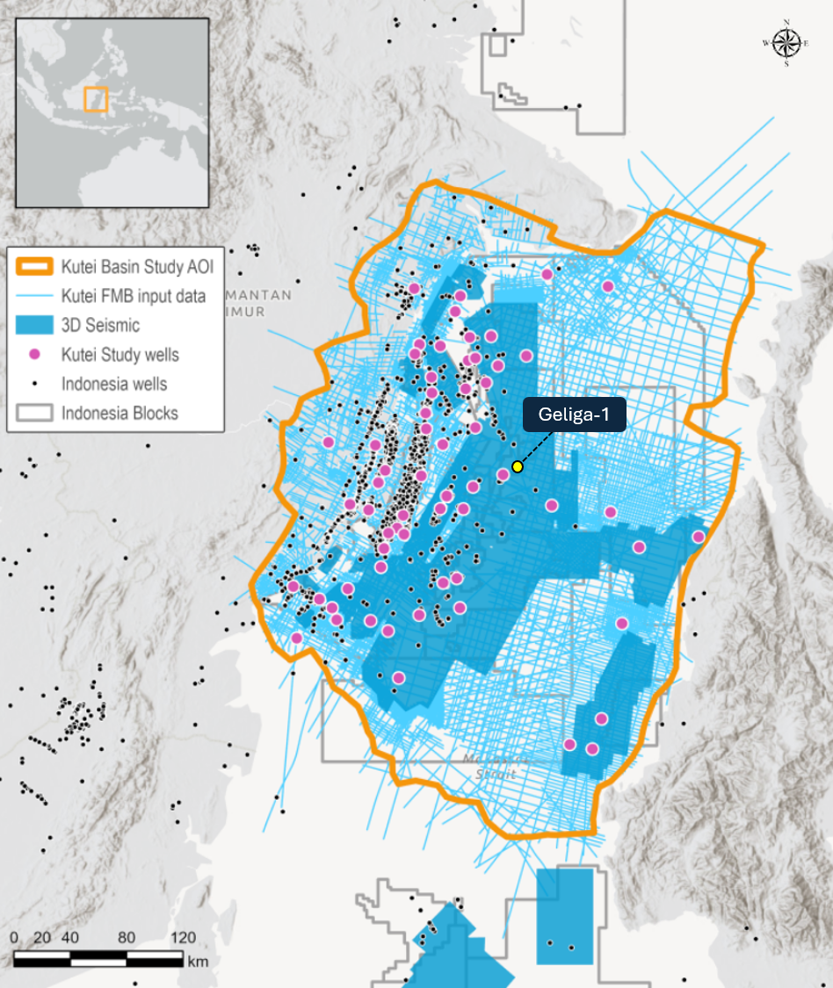
That regional context is the premise behind the TGS Kutei 2D-cubed project. Instead of viewing decades of seismic coverage as disconnected surveys, the project brings 119 seismic vintages, and more than 2,750 lines acquired over five decades (Figure 1) into a continuous interpretable volume. This provides a way to follow geological trends and concepts beyond individual discoveries and across areas with different acquisition histories, processing, quality, and data density.
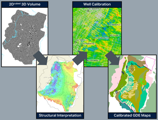
Combined with the TGS Facies Map Browser (FMB), the regional seismic framework supports structural interpretation, calibrated Gross Depositional Environment (GDE) mapping, and fairway analysis. In practical exploration terms, that means examining how sediment pathways, reservoir systems and structural elements evolve across the basin, and testing where prospective conditions may extend and be favorable beyond well control. The interpretation is calibrated with 62 exploration and appraisal wells, incorporating sequence stratigraphy, chrono- and lithostratigraphy, facies and GDE interpretation. Cuttings, core data, well correlations, seismic facies and biostratigraphy help connect well observations to the regional seismic framework, providing the ground-truthing for depositional model extrapolation into the frontier areas (Figure 2).
New wells such as Geliga-1 add to the wider basin exploration picture, this integrated view provides a consistent basis for placing those successes in context and assessing where analogous opportunities may remain.
For companies evaluating opportunities in this area, high-quality regional subsurface data and interpretation will be key to understanding the broader geological context. TGS has the seismic coverage and imaging expertise to help operators move confidently across both mature and frontier areas. Visit TGS seismic data library or contact us to schedule a data showing.
Go Deeper
-
Unveiling the Entire Kutei Basin at Once: https://hubs.ly/Q04DXzF20
-
Learn more about the Facies Map Browser: https://hubs.ly/Q04DXzMf0
-
Integrated Seismic and Stratigraphic Insights into the Depositional Framework of the Kutei Basin: https://hubs.ly/Q04DXz_B0
-
Indonesia Multi-Client Hotspot: https://hubs.ly/Q04DXB770
-
Learn more about 2D-cubed: https://hubs.ly/Q04DXBmM0