Pioneering Marine Seismic Solutions for Evolving Energy Needs

Tailoring acquisition geometries makes it easier to solve imaging challenges, as illumination and data quality increase with the amount and diversity of data acquired. Geophysical objectives and project economics determine the right solution.

From single sail line to full-azimuth coverage TGS provides flexible survey designs that address any subsurface challenges. We optimize the 3D sampling of offsets and azimuths, offering wide-tow sources and dense streamers for improved near-offset distribution, long streamers for accurate velocity model building, or integrated towed streamer and node data.

Smarter Acquisition, Sharper Images

Designed for geophysical flexibility and operational efficiency, GeoStreamer X supports complex survey geometries to meet imaging and characterization demands in any environment.

tgs-check-25

GeoStreamer X multi-azimuth surveys (MAZ) can enhance subsurface illumination, reservoir property determination, and velocity model updates. MAZ can be achieved using one or more vessels.
tgs-check-25

Adding some long streamers to the spread can improve deeper imaging and FWI. In complex salt environments, two or more vessels can significantly extend the long-offset coverage.
tgs-check-25

Additional data from ocean bottom nodes may yield enrich offset or azimuth coverage to improve seismic imaging.
tgs-check-25

Wide-tow source configurations can improve near-offset coverage for shallow imaging and AVO.

Meeting Subsurface Imaging and Characterization Challenges

The GeoStreamer X configuration can be applied to new surveys in new areas or to overshoot existing GeoStreamer data for a rapid upgrade. Acquisition design can include wide-tow sources, dense streamers for improved near-offset distribution, and long streamers for accurate velocity model building. 

GeoStreamer X can be tailored for geological challenges at any depth. The figure  schematically illustrates how the flexible towing and handling capacity of Ramform vessels creates many survey design possibilities to improve both offset and azimuth sampling with the efficiency benefits of GeoStreamer surveys.

Enhanced Shallow Imaging Resolution

These images represent a compelling demonstration of enhanced shallow imaging resolution possible without compromising survey efficiency.

A shallow time slice at 200 ms (bottom left) and a cross-section (top left) for legacy data that used standard triple-source separation of 75 m for a 12x75 m streamer configuration. The corresponding time slice and cross-section (right) for GeoStreamer X with a wide-tow source separation of 350 m and a 14x75 m configuration reveals enhanced image resolution and clarity at all depths.

Unlocking New Exploration Opportunities

The final figure is an example where GeoStreamer X data enabled existing fields and known discoveries in the southern Viking Graben to be accurately mapped and new leads and opportunities suitable for near-field exploration have been highlighted. Evidence of additional nearby hydrocarbon potential has been revealed with an improved understanding and characterization of the various reservoir intervals.

Several additional wells have been drilled, following the Lille Prinsen discovery, to examine the potential in the deeper stratigraphic intervals such as the Jurassic sandstone and the Permian. In the image below, based on our elastic-attributes extraction on the pre-Cretaceous interval, clear indications of hydrocarbons are visible at the Upper Jurassic and Zechstein levels. These anomalies are of reasonable size and could constitute interesting nearfield exploration targets.

GeoStreamerX - Fig3
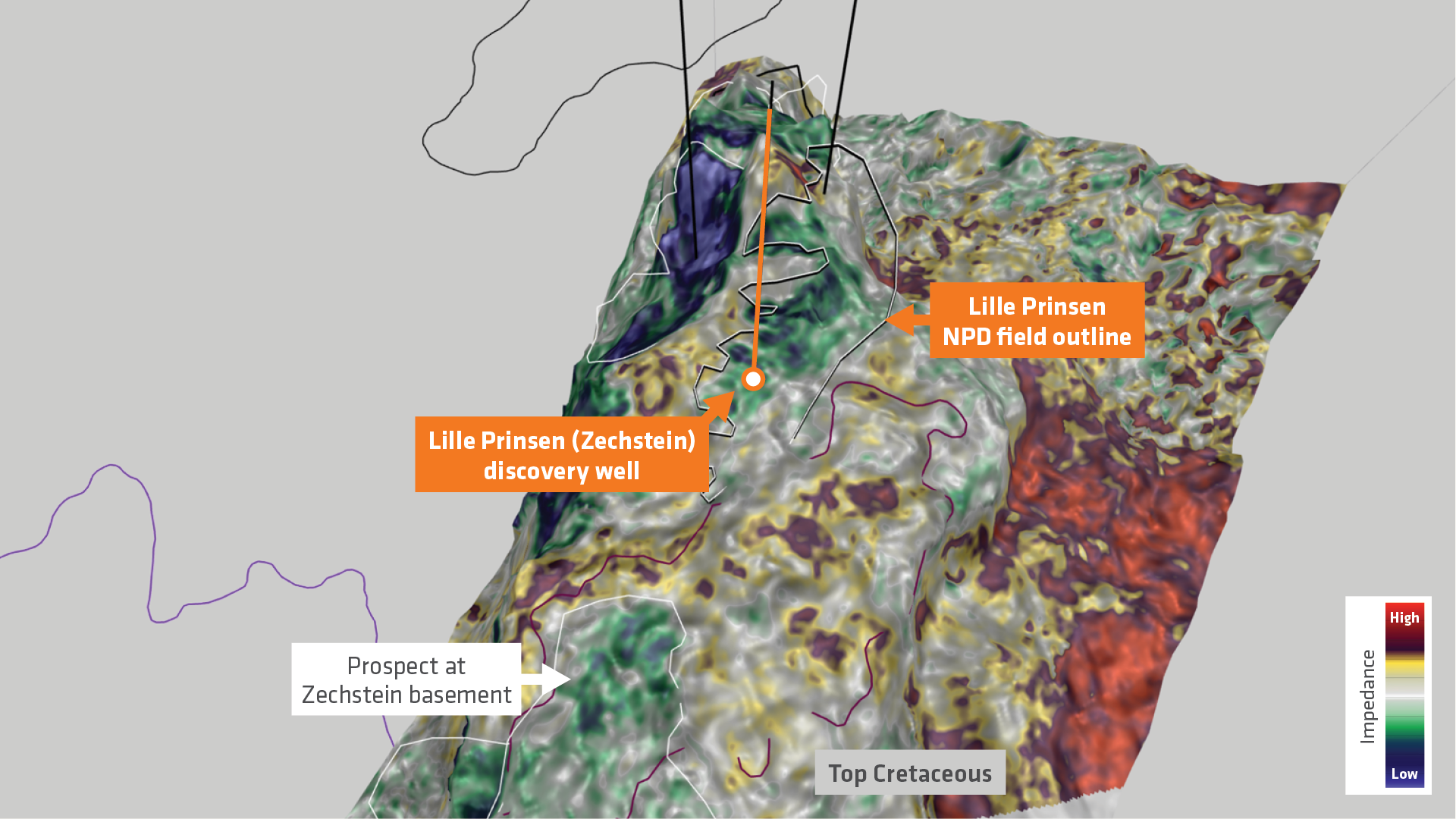
Ultra-far relative impedance map extraction is highly correlated to Vp/Vs at the top Cretaceous over a 16ms window. Blue anomalies match well with the Norwegian Petroleum Directorate (NPD) outline for the Lille Prinsen discovery at this level. A visible anomaly further north-west was tested successfully by a recent appraisal well. Additional opportunities exist to the south of Lille Prinsen, as well as down-flank.

Let’s Discuss Your Acquisition Needs

With the industry’s most diverse fleet and integrated expertise, from survey design and acquisition to seismic data imaging, TGS delivers trusted, tailored solutions for complex exploration challenges.

Learn More About Our Fleet

Discover the capabilities, configurations and proven performance of our diverse fleet. Built for reliability and efficiency, our vessels are ready to meet your exploration needs, anywhere in the world.

Start the Conversation

Every project is different. Talk to a TGS expert about your specific acquisition requirements. With decades of trusted experience and integrated capabilities, we’ll help you design the right solution from the start.