

Why Tanzania?
Tanzania boasts strong play diversity, proven through exploration success across much of the stratigraphy, from Early Cretaceous to Miocene reservoirs. The country's offshore region offers highly attractive petroleum prospects, with over 36 trillion cubic feet of gas discovered through exploration activities by Shell (formerly BG Group) and Equinor in this exciting basin, which remains relatively underexplored and underdeveloped, featuring untested plays and undrilled potential.
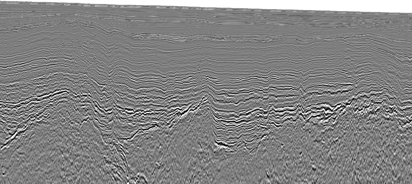
Regional seismic data allows geoscientists to better understand petroleum geology and exploit exploration opportunities.
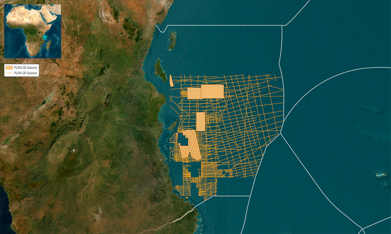
Our Data Coverage
Our Data
TGS holds the exclusive rights to license all of mainland Tanzania’s offshore data on behalf of the government. The agreement also grants TGS the authority to conduct future acquisition of new seismic data and to reprocess existing data. Additionally, it includes support for upcoming licensing rounds, which are anticipated to commence in 2025.
Extensive regional 2D and 3D datasets span an area of more than 132,000 km2, covering the entirety of offshore mainland Tanzania. Well data is also available. This data allows for an interpretation of the entire basin's evolution and structural history, identification of plays and prospect-specific analysis.
The exploration challenge remains to fully understand the maturity and distribution of the source rocks from various ages and the oil-prone source rocks proven and tested at the region's edges. The excellent sands proven over numerous source intervals and the high-quality data available make Tanzania an attractive exploration target.
Tanzania Geology
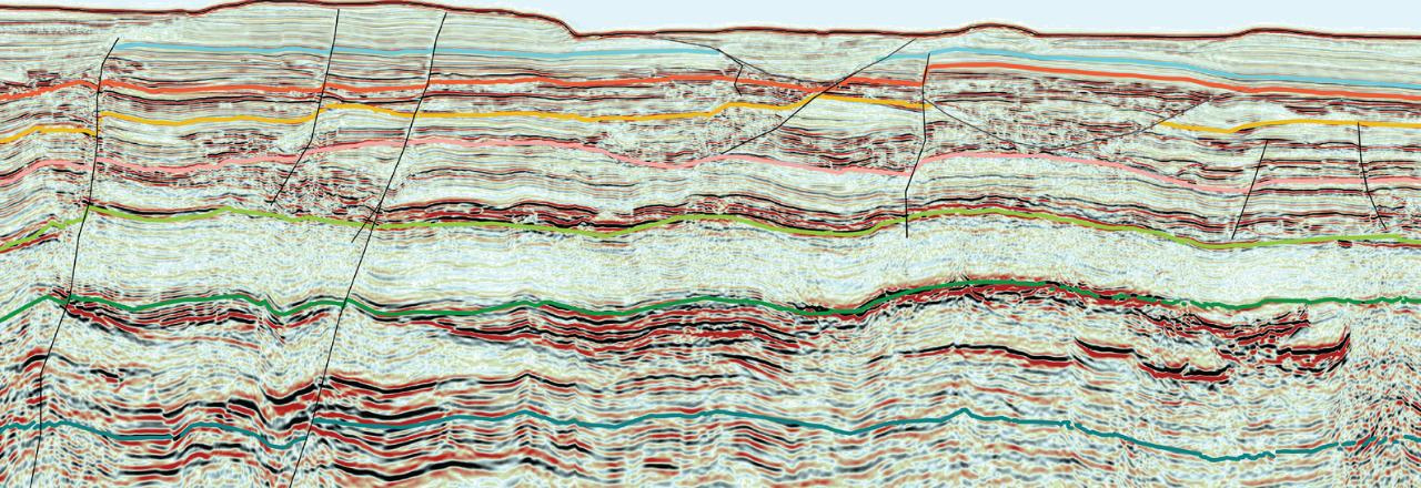
The depositional history of the coastal basin and offshore Tanzania is strongly influenced by the breakup of Gondwana in the Middle Jurassic to Early Cretaceous. Madagascar drifted away from Tanzania, Kenya, and Somalia during the Late Jurassic, followed by the strike-slip movement along the Davie Ridge transform zone. While the separation of Madagascar had initiated the development of a passive margin, the East African rift system is expected to have influenced the structural reactivation and deformation onshore and offshore. These large-scale events along the Seagap Fault and the Kerimbas Graben impact the deposition of reservoir quality and trap formation.
World-class gas fields occur in the Ruvuma Basin, Northern Mozambique, and offshore Tanzania. In northern Mozambique, much of the gas was discovered in the deepwater province of the Oligocene, Eocene, and Paleocene sands (Cenozoic play system). The gas in Tanzania is from the Early Cretaceous play system in addition to the Miocene turbidites sands (Cenozoic play system). The Jurassic-Cretaceous source rocks that have charged the significant gas discoveries are proven offshore East Africa, and the large fault systems help with fluid transfer into shallower reservoirs.
Speak to a Specialist
Interested in a product demo or trial? Let us know your needs and we’ll connect you to the right person or team.
Book a Data Viewing
Want to see the latest seismic data solutions and imaging technologies in your region of interest or for the next license round? Book a data viewing with one of our experts.
Discuss Your Seismic Data Needs
Every need is different and we'd like the opportunity to discuss yours further. Speak to one of our data or geoscience experts to customize seismic solutions specific to your requirements.