Richer Azimuth Geometries
The acquisition of additional azimuths should be tailored to the complexity of the subsurface seismic imaging challenges. Used to boost target illumination, lateral resolution, or improve coherent noise attenuation.
Multi-Azimuth Acquisition with GeoStreamer X
Multi-azimuth (MAZ) acquisition improves subsurface illumination, supporting more reliable reservoir characterization in clastic and carbonate settings not dominated by complex salt. MAZ benefits can be realized by acquiring one or more new azimuths to enhance existing narrow-azimuth legacy data. The resulting survey is formed during processing by integrating data from multiple azimuths. Single-vessel solutions offer a cost-effective approach with lower carbon emissions.
GeoStreamer X surveys apply MAZ shooting templates to improve illumination and may include long streamer tails to efficiently acquire extended offsets for Full Waveform Inversion and velocity model building.
Advantages of Richer Azimuth Geometries

Narrow Azimuth (NAZ)
One vessel towing an array of streamers and source(s), typically along parallel sail lines with a single acquisition azimuth. Cost-effective and operationally efficient for areas with relatively simple geology.

Multi-Azimuth (MAZ)
Two or more coincident surveys acquired with different acquisition azimuths and combined during processing. Improves illumination of subsurface targets, particularly in areas with complex faulting or azimuth-dependent reflectivity.

Wide-Azimuth (WAZ)
Two or more vessels used simultaneously to increase the range of azimuths and offsets available for each shot gather in processing. Enhances imaging beneath complex overburdens such as salt by improving subsurface illumination and velocity model accuracy.

Rich-Azimuth (RAZ)
A rich-azimuth seismic dataset formed by combining multiple wide-azimuth surveys. Provides denser and more uniform azimuth and offset coverage, improving imaging of complex reservoirs and enabling advanced inversion and amplitude analysis.
Enhancing Subsurface Imaging in Complex Geological Environments
Wide-azimuth (WAZ) and rich-azimuth (RAZ) surveys can be effective in attenuating coherent imaging noise in salt provinces and other complex geological environments. These survey types may incorporate extended long-offset (ELO) strategies to improve offset coverage efficiently. A hybrid acquisition approach - using ocean-bottom node (OBN) receivers in combination with towed streamers - can provide complementary data with richer offset and azimuth coverage. This improves Full Waveform Inversion (FWI) velocity model building and supports more detailed subsurface characterization. OBN data may also be used to acquire converted wave (PS) data, supporting joint PP-PS imaging and elastic property analysis.
Acquiring two or more azimuths primarily enhances target illumination and lateral resolution. Wide-azimuth data, typically collected using two or more vessels on parallel sail lines, improves coherent noise attenuation. This is particularly valuable in areas with complex overburden, such as salt, where ELO strategies may also be applied.
Rich-azimuth acquisition combines wide-azimuth, multi-vessel geometries with multi-azimuth shooting templates to deliver maximum target illumination and coherent noise suppression. It is generally reserved for the most challenging imaging scenarios. In cases where rich-azimuth towed-streamer designs do not fully address imaging challenges, sparse OBN deployment can be added to improve offset-azimuth coverage. Converted wave data from the nodes may further support elastic reservoir property prediction. Standalone OBN acquisition with dense node spacing is typically limited to reservoir-scale projects due to higher cost and operational complexity.


Multi-Azimuth Subsurface Characterization
A GeoStreamer X survey in the South Viking Graben demonstrates how high-density multi-azimuth (MAZ) acquisition, combined with long streamer tails (10 km) and wide-tow triple-source shooting (225 m outer source separation), can deliver several key advantages. These include enhanced resolution in the shallow section, improved deep velocity model building through Full Waveform Inversion (FWI), and a reliable multi-azimuth inversion of pre-stack amplitude versus angle (AVA) data.
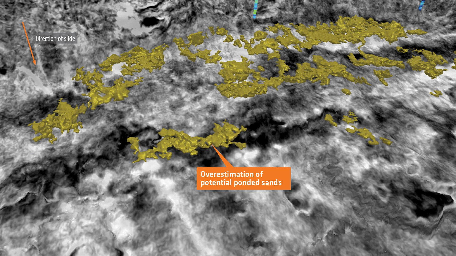
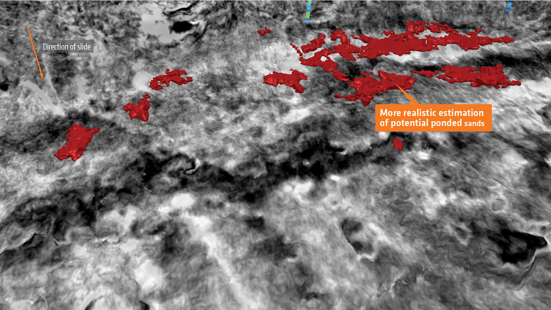
The figure illustrates how MAZ subsurface characterization can reduce uncertainty in the spatial delineation of reservoir properties.
Comparison: Estimation of Porosity and Geobody Extraction. The legacy narrow-azimuth (NAZ) dataset (left) shows porosity estimates that are noisier and less geologically consistent compared to those from the newly acquired and processed GeoStreamer X MAZ dataset (right). Relying on the NAZ data alone could lead to an overestimation of porous sand volumes, increasing the risk of poor drilling outcomes.
Let’s Discuss Your Acquisition Needs
With the industry’s most diverse fleet and integrated expertise, from survey design and acquisition to seismic data imaging, TGS delivers trusted, tailored solutions for complex exploration challenges.
Learn More About Our Fleet
Discover the capabilities, configurations and proven performance of our diverse fleet. Built for reliability and efficiency, our vessels are ready to meet your exploration needs, anywhere in the world.
Start the Conversation
Every project is different. Talk to a TGS expert about your specific acquisition requirements. With decades of trusted experience and integrated capabilities, we’ll help you design the right solution from the start.