

Backscatter map with water column anomalies over a live seep
Why Nigeria?
The offshore Nigerian shelf is West Africa's most prolific hydrocarbon province, boasting multiple billion-barrel discoveries and decades of successful production. Nigeria remains a major oil producer in Africa, with approximately 37 billion barrels of oil reserves, ranking among the top ten globally. The country produces between 1.3 and 1.8 million barrels of crude oil daily and has over 200 trillion cubic feet of natural gas reserves, with the potential to reach 600 trillion cubic feet.
At TGS, in partnership with PetroData, we are committed to providing top-tier data in the region. Our datasets include the Nigeria MegaSurvey and MegaSurveyPlus which provide mega-regional 3D seismic coverage, the recently completed Nigeria Vision and Awele deepwater 3D PSDM datasets, Vintage 2D seismic and a deepwater 2D survey reprocessed to PSDM in 2019.
These seismic datasets are complemented by a comprehensive regional Multibeam and Seafloor Sampling (MB&SS) study, and a pioneering geochemical coring project. These resources are uniquely positioned to evaluate a wide range of exploration opportunities in open and deepwater acreage.
Data Library
Search our interactive map portal to see the industry-leading subsurface data we offer in Nigeria. View available data types, projects and deliverables in your areas of interest.

Nigeria License Round 2025
The Nigerian Upstream Petroleum Regulatory Commission (NUPRC) is offering 50 blocks in its 2025 licensing round, including 21 shallow water blocks and one deepwater block. The remaining 28 blocks are located onshore across the Niger Delta and the Benue Trough/Anambra Basin further inland. Prequalification is expected to close February 2026, and bidding will be overseen by the NUPRC and scheduled to conclude by July 2026.
TGS is supporting this round with a suite of offshore subsurface data, including 2D and 3D seismic, multibeam, coring, and geochemical programs – the first of its kind in the region. Our multibeam and seafloor sampling dataset, which is mandatory for all pre-qualified bidders, covers approximately 82,000 km2 and provides a fresh perspective on exploration plays in deep-water Nigeria, offering fresh insights to prospective bidders for exploration risk management and aligning with the government's goals of reserve maturation and production optimization.


Awele 3D: Deepwater PSDM
The Awele 3D multi-client seismic program, which commenced acquisition in Q3 of 2023, aims to enhance Nigeria’s energy potential by providing valuable data insights into untapped hydrocarbon resources and revealing prospectivity in the offshore deep and ultra-deep waters of the Niger Delta Basin.
Final PSDM products (approx. 11,430 km2) featuring a high-resolution velocity model with FWI integrated with tomography are available now. TGS is showcasing the prospectivity and de-risking drilling operations in one of Africa's largest and oldest hydrocarbon producers will further bolster Nigeria’s energy production capacity to meet the rising energy demand.
Nigeria's Deepwater Potential
With significantly improved imaging of more than 17,000 km of PSDM reprocessed 2D seismic offshore Nigeria, TGS-PD data will enable a better understanding of the petroleum system of the deepwater offshore area. TGS depth imaging creates more accurate dip and realistic volume interpretation of features of interest. The potential for new license rounds over the deepwater open blocks, in conjunction with lower-risk petroleum play concepts, could once again establish Nigeria as West Africa’s flagship country for exploration.
More than ten currently producing fields in water depths of 1,000 m to 3,000 m confirm source rock presence and maturity in the deepwater region offshore Nigeria. These indicate that the Akata formation shales can be mature for oil further outboard than the shelf and that there are feasible migration paths and trap charge scenarios in the distal part of the delta lobes. This makes prospects further outboard viable, such as those identified in the outer fold and thrust belt. Structural analyses on the fault and thrust patterns and detachment mechanisms of the margin slope show various viable setups of charging several folds and thrusts along the slope.
Nigeria License Round 2025
TGS offers various data types to explore Nigeria's offshore waters. Alongside seismic data, we also present a unique regional Multibeam and Seafloor Sampling (MB&SS) study to provide cost-effective insight into the seafloor. These data sets, combined with our geochemical analysis, will allow explorers to evaluate a variety of open and deep-water acreage exploration opportunities.
.png?width=2000&height=1125&name=Nigeria_2025_Licensing_Round%20(2).png "Nigeria_2025_Licensing_Round (2)")
Data Availability
- 76,000 sq km of Nigeria MegaSurvey 3D seismic
- 11,231 sq km of Nigeria MegaSurveyPlus 3D PSTM
- 11,430 sq km of Awele 3D PSDM
- 2099 sq km of Nigeria Vision PSDM
- 16,700 line km of Nigeria MegaSurvey 2D
- 17,874 line km NGRE19 2D multi-client seismic - formerly named the VERNG9899 survey, reprocessed to PSDM by TGS in 2019
- 2,048 line km NG02 2D multi-client seismic
- 82,000 sq km Multibeam and Seafloor Sampling (MB&SS) - 1,223 active hydrocarbon seeps detected
- Interpretation Products
- Drop Coring - including 17 seabed heat flow measurements and 253 cores
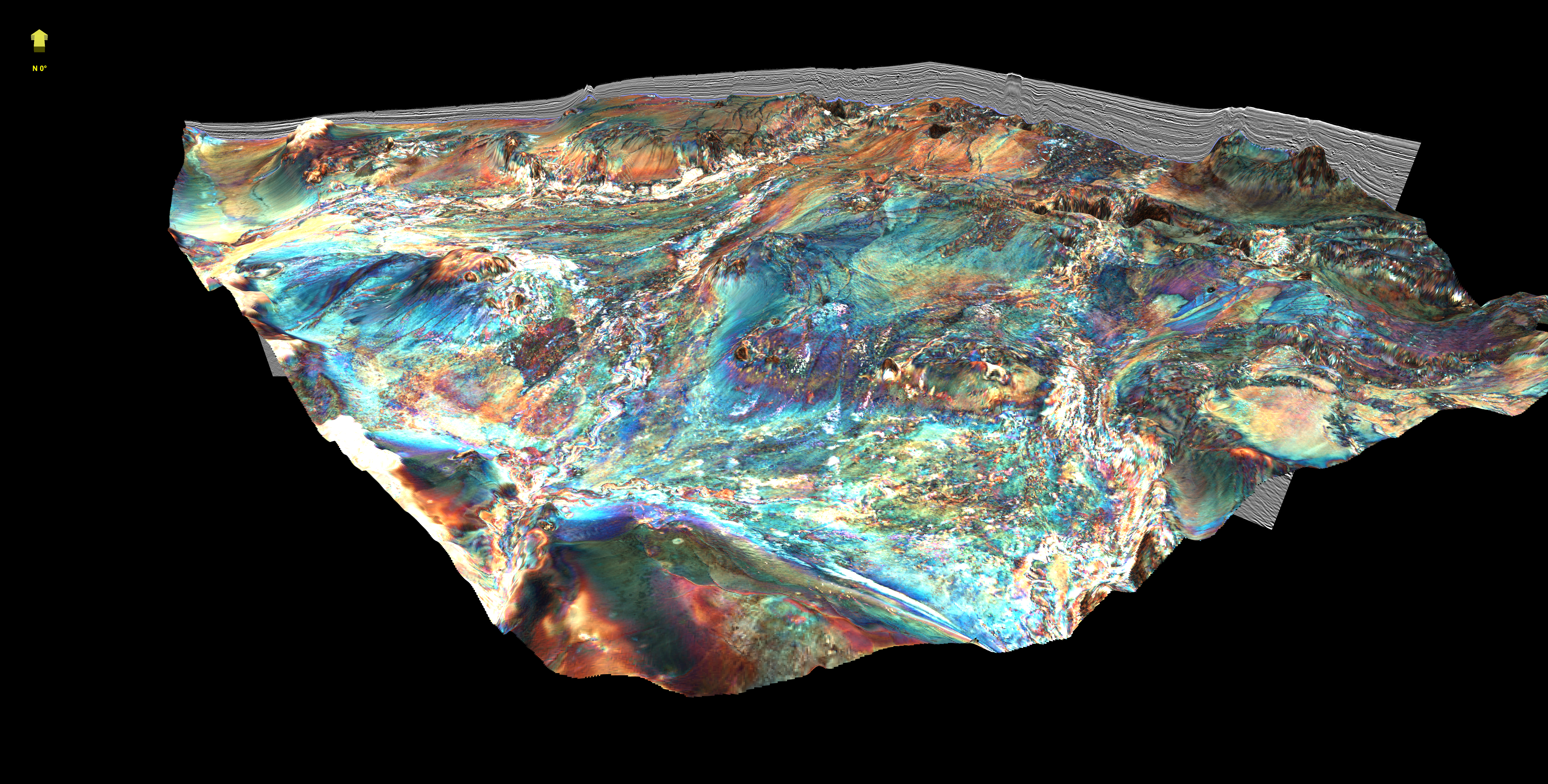
Multibeam
Multibeam bathymetry and backscatter surveys provide a comprehensive view of the seafloor, complementing traditional tools such as seismic, gravity and magnetics. TGS has acquired over 82,000 km2 of multibeam data at water depths between 750-3,500 meters, and have high-graded the huge amount of anomalies identified in the data.
| Block Name | License Round Packet | Area (sq. km) | TGS 2D (km) | Data Coverage (2D km/3D sq. km) |
Wells | Water depth (m) min | Water depth (m) max |
|---|---|---|---|---|---|---|---|
| PPL2A31 | Download | 42 | 3D | 158 | 1 | 12 | 12 |
| PPL2A33 | Download | 188 | 2D/3D | 222/2896 | 2 | 101 | 101 |
| PPL2A34 | Download | 27 | 3D | 460 | 1 | 23 | 23 |
| PPL2A35 | Download | 94 | 2D/3D | 222/2896 | 1 | 85 | 85 |
| PPL2A36 | Download | 17 | 2D/3D | 1/41 | 1 | 7 | 7 |
| PPL2A37 | Download | 62 | 2D/3D | 3/12 | 2 | 20 | 20 |
| PPL2A39 | Download | 13 | 3D | 123 | 2 | 20 | 20 |
| PPL2A40 | Download | 21 | 3D | 627 | 2 | 24 | 24 |
| PPL2A41 | Download | 22 | 3D | 910 | 2 | 15 | 15 |
| PPL2A42 | Download | 10 | 3D | 910 | 2 | 38 | 38 |
| PPL2A44 | Download | 36 | 3D | 627 | 1 | 22 | 22 |
| PPL2A45 | Download | 21 | 3D | 255 | 1 | 6 | 6 |
| PPL2A46 | Download | 93 | 3D | 1295 | 1 | Onshore | Onshore |
| PPL2A47 | Download | 68 | 3D | 1295 | 1 | Onshore | Onshore |
| PPL2A49 | Download | 69 | 3D | 46 | 1 | Onshore | Onshore |
| PPL2A51 | Download | 26 | 3D | 159 | 1 | Onshore | Onshore |
| PPL2A52 | Download | 76 | 3D | 278 | 3 | 67 | 67 |
| PPL2A53 | Download | 38 | 3D | 343 | 4 | 18 | 18 |
| PPL2A55 | Download | 21 | 3D | 656 | 1 | 30 | 30 |
| PPL2A56 | Download | 61 | 3D | 627 | 3 | 30 | 30 |
| PPL2A57 | Download | 14 | 3D | 910 | 1 | 23 | 23 |
| PPL2A58 | Download | 170 | 2D/3D | 195/112 | 1 | 60 | 200 |
| PPL2A60 | Download | 312 | 3D | None | 327 | 7 | 60/105 |
| PPL2010 | Download | 642 | 2D/3D/MBSS | 142/835/642 | 0 | 1000 | 2000 |
Mini Bid Round
The Federal Government of Nigeria has opened a mini-bid license round to explore and exploit petroleum opportunities. Seven deep offshore oil and gas blocks are on offer, with the round providing interested parties the chance to invest in the region's potential for oil and gas.
TGS-PetroData is pleased to welcome potential bidders to come and view our data packages covering the seven blocks. We offer data from our newly acquired offshore multibeam, coring, and geochemical program (the first of its type in the region), with its interpretation from newly reprocessed deep-water 2D data set, to provide a new de-risking angle to the exploration plays in the deep-water region.

Nigeria Mini Bid Round - 7 license blocks
Speak to a Specialist
Interested in a product demo or trial? Let us know your needs and we’ll connect you to the right person or team.
Book a Data Viewing
Want to see the latest seismic data solutions and imaging technologies in your region of interest or for the next license round? Book a data viewing with one of our experts.
Discuss Your Seismic Data Needs
Every need is different and we'd like the opportunity to discuss yours further. Speak to one of our data or geoscience experts to customize seismic solutions specific to your requirements.