


The Location
Location
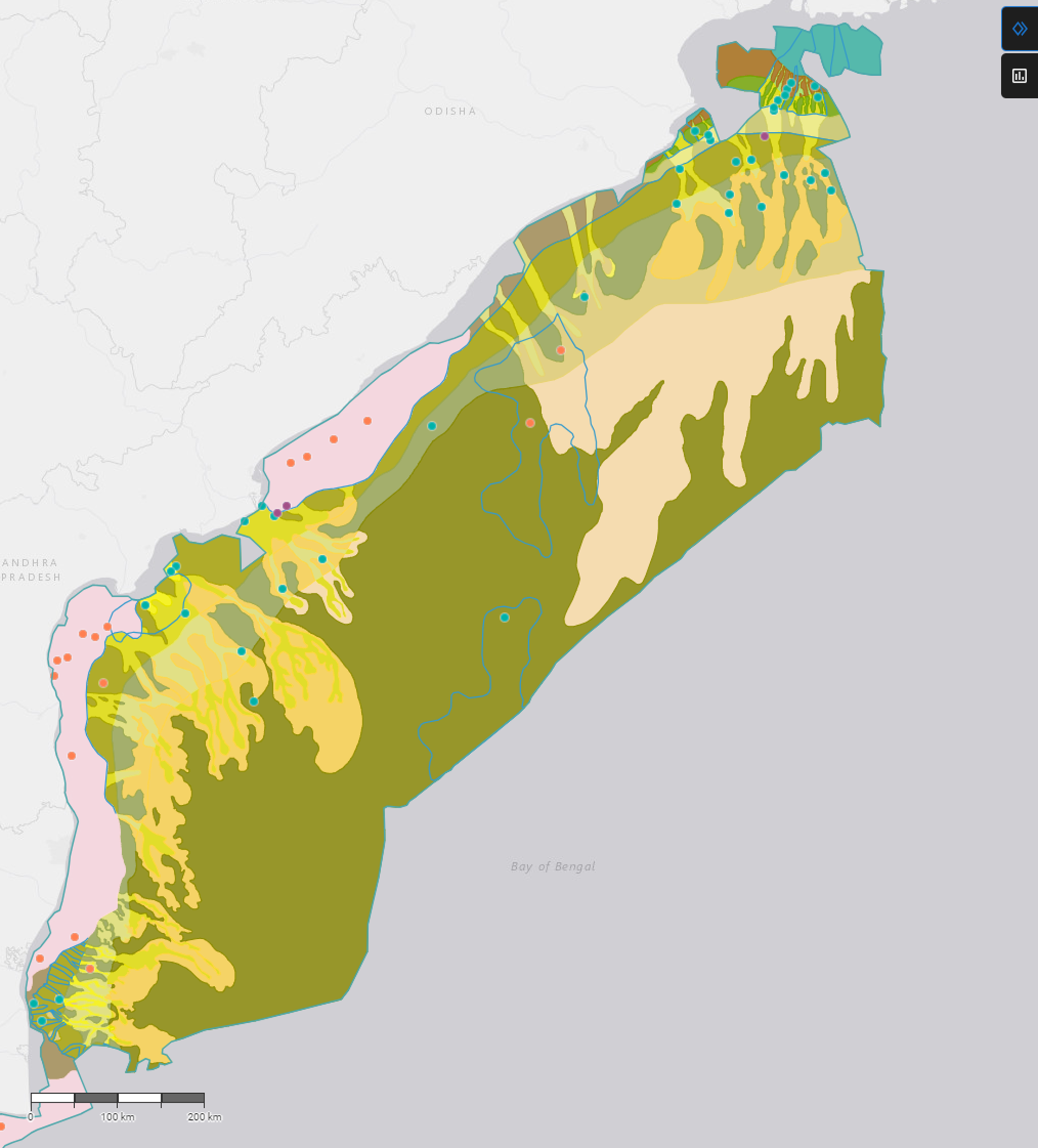
Cauvery, Krishna-Godavari and Mahanadi basins, Offshore India
Survey
India 2D Cubed East Coast
Date Processed
2023
Data Type
2D Seismic lines
Data Deliverables
3D Volume, Survey-matched 2D Lines, Velocity Model, Attributes
Survey Type
Regional stratigraphic / GDE study
Survey Size
~525,000 km²

The Challenge
Multi-Vintage Legacy 2D Grid
The East India offshore region contains an extensive archive of 2D seismic data acquired over several decades, spanning multiple contractors/operators, vintages and geometries. These surveys had various phases, amplitudes and time shifts, making it impossible to perform reliable, basin-wide seismic horizon mapping.
Without a unified, spatially consistent dataset, correlating well tops and stratigraphic events across the Cauvery, KG, and Mahanadi basins in a coherent manner was extremely challenging, limiting the value of the existing data for regional exploration decisions.

Absence of 3D Volume for Stratigraphic Mapping
No contiguous 3D seismic volume existed across the full extent of the three basins. With only isolated 2D profiles, generating regionally consistent GDE maps and sediment fairway reconstructions was not feasible using standard interpretation tools.
The absence of a 3D volume limited the use of powerful 3D seismic attributes routinely applied for facies discrimination and structural mapping in analogous basins. Interpreters were forced to work with isolated surveys, making it extremely difficult to trace stratigraphic horizons between regions, identify subtle structural features, or map key geological events.
The lack of spatial continuity was a major impediment to regional play mapping and identifying prospective deepwater fairways extending from the shelf into the deep basin.


The Solution
Data
- Multi-vintage 2D seismic
- 60 key wells, 21 with biostratigraphy
Pre-Processing Solution(s)
Modern broadband processing, including:
- ML-driven signal processing
- Data assessment and quality control
VMB and Imaging
- 3D RMS velocity across all surveys
- 2Dcubed structurally conformable interpolation engine
Subsurface Interpretation
Data Management
- Imaging AnyWare® platform
TGS applied its proprietary 2Dcubed technology to convert the multi-vintage 2D grid into a continuous, interpretable 3D volume. With over 3,000,000 km² of data processed across dozens of basins worldwide, from sparse vintage grids to dense modern surveys, 2Dcubed has a proven track record of delivering fit-for-purpose 3D volumes while minimizing input data variability. 2Dcubed is a structurally conformable interpolation engine that uses a six-step workflow, beginning with demigration to a common datum and global phase, amplitude, and time matching to create a unified 2D dataset. Dip and coherence attributes then guide geology-driven 3D interpolation that honors subsurface structure. The final 3D volume was delivered at 50 x 50 m bin spacing with a confidence attribute, survey-matched 2D lines, and a 3D RMS velocity field.
Alongside the 2Dcubed workflow, TGS offers tailored 2D post-stack processing, including advanced machine learning (ML) to enhance signal quality, suppress noise, and improve stratigraphic resolution in legacy datasets. Depending on project goals, budget, schedule, and data availability, the 2D data can also be reprocessed from raw gathers before 2Dcubed to further improve imaging, noise attenuation, bandwidth, and the final 3D volume.

The Results
Key Play Fairways Revealed by GDE Maps
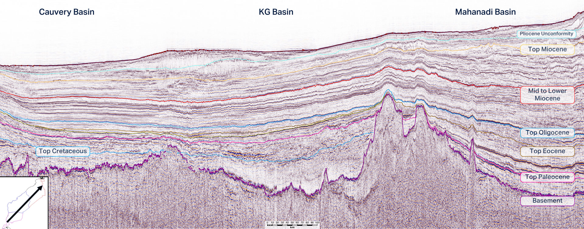
Using the 2Dcubed 3D volume, the project generated a comprehensive suite of GDE maps across multiple stratigraphic sequences from the Upper Cretaceous through to the Upper Miocene. The maps revealed the structural influence of the 85-degree Ridge on depositional patterns in the Cretaceous, the development of carbonate systems in the Eocene, and the impact of Bengal Fan progradation on Miocene and younger sequences in the Mahanadi Basin. The continuity of the 2Dcubed volume enabled tracking of shelf-break migration and deepwater fairway evolution, critical inputs for high-grading exploration targets and planning future 3D survey acquisition.
Consistent Stratigraphic Framework Across All Three Basins
The 2Dcubed volume enabled a consistent, age-calibrated sequence stratigraphic interpretation spanning the Cauvery, KG, and Mahanadi basins for the first time. Eight to nine key seismic horizons were mapped per basin, from the Cretaceous basement through to the Pliocene, with cross-basin correlations validated against well data and biostratigraphy.
The project revealed significant inconsistencies in operator-reported formation tops, some mis-picked by over one kilometer, particularly in the Mahanadi Basin where reworked sediments from the Bengal Fan had complicated earlier interpretations. The unified 3D framework resolved these discrepancies and delivered a coherent regional geological model.
Conclusion
The East India 2Dcubed project demonstrated how legacy multi-vintage 2D seismic data can be transformed into a unified regional exploration framework spanning the Cauvery, KG and Mahanadi basins. By converting fragmented 2D datasets into a continuous 3D seismic volume, TGS enabled consistent sequence stratigraphic interpretation, regional GDE mapping and basin-scale geological understanding across approximately 525,000 km² of offshore India.
The project resolved long-standing inconsistencies between surveys and well correlations, while providing interpreters with a modern 3D environment for evaluating deepwater exploration potential. The resulting dataset established a scalable foundation for future regional studies, prospect screening and focused 3D acquisition programs across India’s east coast.
Commercial impact
Reduced Regional Exploration Uncertainty
A unified stratigraphic framework increased confidence in basin-scale interpretation and prospect screening across offshore basins.