Vast Wind Data Analytics Potential at your Fingertips
Data and insight for every stage across the entire wind development project at your fingertips whenever you need it.
Introducing Wind AXIOM
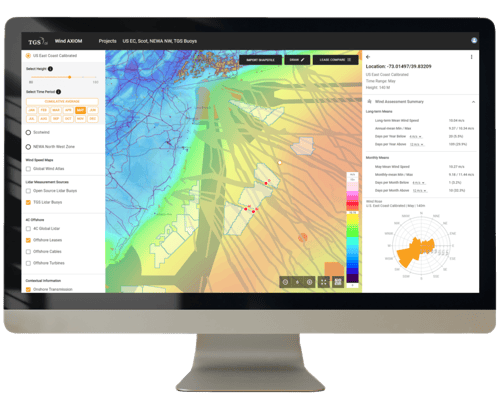
Wind AXIOM is a new insight platform that helps wind developers explore high-value areas, prepare bids and develop leases. With easy access to vast amounts of data and advanced analytical tools, Wind AXIOM liberates wind development from spreadsheets and finally takes it to another level - an integrated data map.
Why Wind AXIOM?
Complete
Getting your hands on the right data for site-specific analysis is cumbersome. Through Wind AXIOM, we aggregate data from multiple sources, refine it, make it comparable, and add high-quality insights. As a result, Wind AXIOM offers the industry's most complete data and insight platform for wind feasibility studies.
Convenient
Managing huge files from different sources is a complicated and expensive task. Wind AXIOM takes that burden away. We have developed a platform that provides easy access to vast amounts of site-specific data in the cloud, cost-effective and secure.
Fast
Wind AXIOM is lightning fast. In our application, you might calculate energy and revenue outputs up to 90% faster than with previous technologies. Draw a lease on a map, select your data layers of choice, and complete your site assessment. What used to take days is done within seconds.
Experienced
TGS, one of the world's leading providers of data and insight to the energy industry, developed Wind AXIOM. We understand the complexity of energy projects and have helped wind market players succeed for more than 20 years. With Wind AXIOM, we have developed a unique platform to contribute to the industry's success and a common goal: the energy transition.
Wind AXIOM Subscriptions
Explorer
US $5,100 / Year
Includes 5 users, billed annually.
Fast, reliable pre-feasibility evaluation for business developers at an unrivaled price.
- Features
- Data
- Access to global wind resource data sources
- One-click assessments incl. Annual Energy Production (AEP) and revenue expectation
- Comparison between portfolios and leases
- Project and portfolio scenario builder
- Team sharing
- Time series and .wrg files download*
- API*
* Included in Explorer+ license, US$10,200 / year. Includes 5 users. Billed annually.
- ERA5 at 8 different hub heights up to 205m
- New European Wind Atlas (NEWA) at 3 hub heights up to 200m
- Global Wind Atlas at 5 hub heights up to 200m
- In-app usage of commercial and contextual data
Bid Developer
US $22,200 / Year
Includes 5 users, billed annually.
Allow cross-functional teams to understand leases' true energy potential and reduce uncertainty in offshore focus areas.
- Features
- Data
- All features in the Explorer tier, plus:
- High-resolution wind model baseline datasets
- Everything in Explorer level, plus:
- Calibrated, high-resolution wind model baseline datasets over key lease rounds, including:
- Central Atlantic (US),
- Carolinas (US),
- California (US),
- Oregon (US),
- Scotland (UK),
- Campos (BR)
Lease Developer
Pricing on request
Access bankable-quality wind measurements at reduced costs using TGS' multi-client floating LiDAR model.
- Features
- Data
- All features in the Bid Developer tier, plus:
- Bankable floating LiDAR data
- Floating LiDAR campaign management
- Everything in Bid Developer level, plus:
- Bankable quality Wind, Metocean and Environmental observations in your choice of location from our constellation of Floating Lidar Systems.
No Obligation Trial
The Wind AXIOM Team is here to help.
TGS is here to provide data-inspired insight to fuel your investment decisions and fast-track your development journey across the wind development process. Contact us to discuss how TGS can provide you with the right data at the right time. Let us create real, actionable insight and next-generation data solutions to put the power of wind firmly in your hands.


Market Intelligence Subscriptions
Wind AXIOM incorporates unique and detailed information through our leading market intelligence database, available through the ForeSEE sister platform. For a complete global offshore wind marketing intelligence overview, TGS offers separate subscription options.
Site-Specific Model Data
Data is the core of Wind AXIOM. We aim to provide the most relevant data at every stage across the entire wind development project - whenever you need it. For this purpose, we source publicly available data in our database and cooperate with numerous partners.
Wind Models
| Global Wind Atlas | New European Wind Atlas | ERA5 | TGS Wind Model | 3E Virtual Met Mast (VMM) | |
|---|---|---|---|---|---|
| Category | Raw - Public | Raw - Public | Refined - Commercial | Refined - Exclusive | Refined - Exclusive |
| Coverage | Onshore: global Offshore: up to 200 km |
Onshore: EU plus Turkey Offshore: 100 km plus complete North and Baltic Seas |
Onshore: global Offshore: global |
Central Atlantic Call Areas, Scotland, California, Oregon, Carolinas, Campos |
SNII, Norway Central Atlantic Call Areas, US, Other locations on demand |
| Period | 40 years | 10 years | 40 years | 11 years | 30 years |
| Start / End Date | Jan 1979 to Aug 2019 | Jan 2009 to Dec 2018 | Jan 1980 to Today | Jan 2010 to Dec 2020 | Jan to Dec 2018 |
| Resolution - Spatial | 3 km | 3 km | 30 km | 1 km | Point specific locations generated from 3m spatial grid |
| Resolution - Temporal | 6 hr | 30 min | 1 hr | 1 hr | 10 min |
| Heights | 10, 50, 100, 150, 200m | 100, 150, 200m | 10, 31, 54, 79, 107, 137, 170, 205m | 80, 100, 120, 140, 160, 180m | 100, 150m |
| Model | Wind Speed maps | Numerical Weather Prediction | Numerical Weather Prediction | Numerical Weather Prediction | Microscale timeseries |
| Model Versions | - | - | - | Uncalibrated, Calibrated (public data), Calibrated (TGS data) |
- |
| Update Schedule | Static | Static | Monthly | Annually | - |
| Uncertainty | High | Medium | High | Low | - |
| Energy Output in Wind AXIOM | No | Yes | Yes | Yes | - |
| Export | No | Yes | Yes | Yes | Yes |
| Wind AXIOM Package Inclusion | Explorer Bid Developer Lease Developer |
Explorer Bid Developer Lease Developer |
Explorer Bid Developer Lease Developer |
Bid Developer Lease Developer |
Add-on to any package |
Partner Data

TGS is working with 3E to further increase model-derived resources in key offshore lease areas, including the US, Norway and other offshore wind leasing roadmap locations. 3E’s Virtual Met Mast (VMM) product provides an ideal substitute for real-world observations where measurements are yet to be acquired and operators demand high-time resolution long-term time series. Pre-computed VMM time series are provided in Wind AXIOM as an add-on for existing subscribers.
- 10mn microscale time series generated at the highest horizontal resolution of 30x30m
- Available anywhere across the globe, for your onshore and offshore projects
- Any height from 10m to 300m, allowing shear calculation
- Any selectable period with a duration of up to 30 years.
- Computed at lightning speed: in less than 24h
- Includes wind speed, wind direction, air density, turbulence intensity and many others.
- Validated extensively against onshore and offshore measurements
- High performance against reanalysis models such as ERA5, NEWA

Lease Coverage
With Wind AXIOM, we offer developers the correct data at a suitable resolution to prepare proposals and bring leases to final investment decision. We offer comprehensive, unique, high-quality data for the respective leases.
| Region | Lease Round | Wind AXIOM Subscription |
|---|---|---|
| North America | New York Bight | Lease Developer |
| North America | Carolina | Bid Developer |
| North America | Central Atlantic | Bid Developer |
| North America | California | Bid Developer |
| North America | Oregon | Bid Developer |
| Europe | UK | Bid Developer |
| Europe | Norway | Bid Developer |
| South America | Brazil | Bid Developer |
Contextual Resources
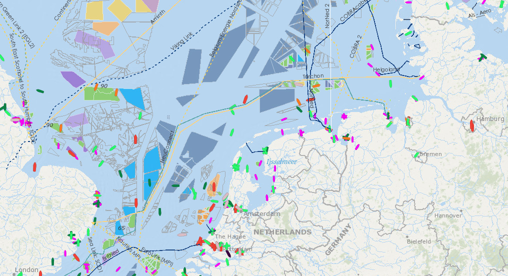
In Wind AXIOM, you have access to globally consistent contextual data resources.
| Theme | Subcategories | Description | Value | Sources Include |
|---|---|---|---|---|
| Environmental & Fishing |
|
In-app and GIS service access to globally consistent coverage polygons describing Environmentally sensitive areas and high fishing activity, with links to web resources where available. | Understand the distribution of environmental risks surrounding planned wind farms, including in-app spatial analysis of those that encroach into planned projects. Design new project proposals to avoid areas that could involve increased permitting schedules. | EMODnet, marine cadastre, BOEM, fws, WRI, EU habitats/birds directives, Fiskeridir, Miljodirektoratet, JNCC, Scottish gov |
| Marine Space Restrictions |
|
In-app and GIS service access to globally consistent coverage polygons describing Marine Space Use Restrictions with links to web resources where available. | Understand the distribution of other marine space users that would impact the construction of offshore wind farms and export cables. Includes in-app spatial analysis of those that encroach into planned projects. Design new project proposals to avoid areas that could involve increased permitting schedules. | NGA, EMODnet, US Army Corps of Engineers, NPD, OGA, marine cadastre, BOEM |
| Bathymetry |
|
Globally consistent view of water depth and bathymetric slope angle. | Instantly understand the water depth setting of planned projects. | GEBCO |
| Onshore Transmission |
|
Globally consistent map of onshore power lines and renewable infrastructure | Understand proximity to onshore power network including in-app spatial analysis of nearest distance to onshore transmission. | Open Street Map |
Contact the Wind AXIOM Team
The Wind AXIOM Team is here to help
TGS is here to provide data-inspired insight to fuel your investment decisions and fast-track your development journey across the wind development process.
Contact us to discuss how TGS can provide you with the right data at the right time. Let us create real, actionable insight and next-generation data solutions to put the power of wind firmly in your hands.

