


The Location
Location
Kutei Basin, Indonesia
Survey
Kutei 2Dcubed
Date Processed
2025
Data Type
Multi-vintage legacy 2D/3D seismic; Well data
Data Deliverables
3D volume, survey-matched 2D Lines, regional velocity model, interpretive products
Survey Type
Regional stratigraphic / GDE study
Survey Size
Over 110,000 km²

The Challenge
Complex Depositional Evolution Across the Basin
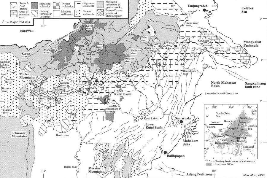
The Kutei Basin records a complex history of Eocene extension, post-rift subsidence, basin inversion, Mahakam Delta progradation, deepwater sedimentation and deformation associated with the West Sulawesi Fold Belt. Understanding how these events controlled reservoir distribution required more than local interpretation.
The project needed to reconstruct depositional change through time, correlate wells across different structural provinces and delineate the regional relationships between sediment pathways, shelf development, structural highs, deepwater systems and carbonate growth.
Fragmented 2D Limited Regional Interpretation
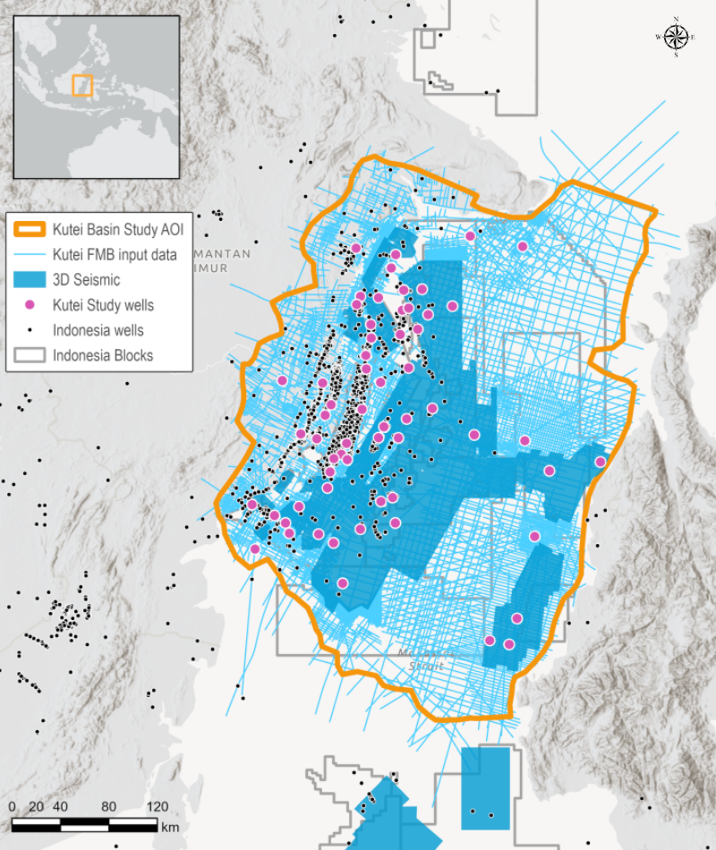
The available seismic comprised 119 vintages and more than 2,750 lines acquired over five decades, with differences in acquisition history, processing, quality and spatial density. Historical exploration focus had also produced uneven data coverage across the basin. Although the individual lines contained valuable subsurface information, interpreting them as separate surveys restricted continuous mapping between lines and across survey boundaries.
A regional solution was needed to turn this extensive but scattered archive into a consistent, basin-scale interpretation framework.
Sparse and Variable Well Control
Much of the project area is undrilled or has limited well penetration, making seismic data essential for extending geological trends between boreholes. The 62 selected wells also contained varying levels of information, influenced partly by well age and the quality of older reports. Establishing reliable regional correlations therefore required consistent log conditioning, lithological interpretation and integration of available core, cuttings, biostratigraphic and petrophysical information before the wells could provide effective calibration across the basin.
Remaining Potential Requires Regional Context
Despite more than a century of exploration, recent discoveries confirm that the Kutei Basin retains significant potential. The main Mahakam Delta play is mature, while deeper-water areas and secondary plays remain less fully evaluated.
Identifying the next opportunities required an integrated regional view capable of connecting structural development with reservoir fairways and depositional environments. Exploration teams also needed an efficient screening platform that could provide basin-wide context without first undertaking complete reprocessing of every survey or committing immediately to regional new acquisition.


The Solution
Data
- Multi-vintage 2D / 3D seismic
- 62 wells
Pre-Processing Solution(s)
- Broadband signal processing
- Rigorous data quality control
VMB and Imaging
- 3D RMS velocity across all surveys
- 2Dcubed structurally conformable interpolation
Subsurface Interpretation
Imaging Software
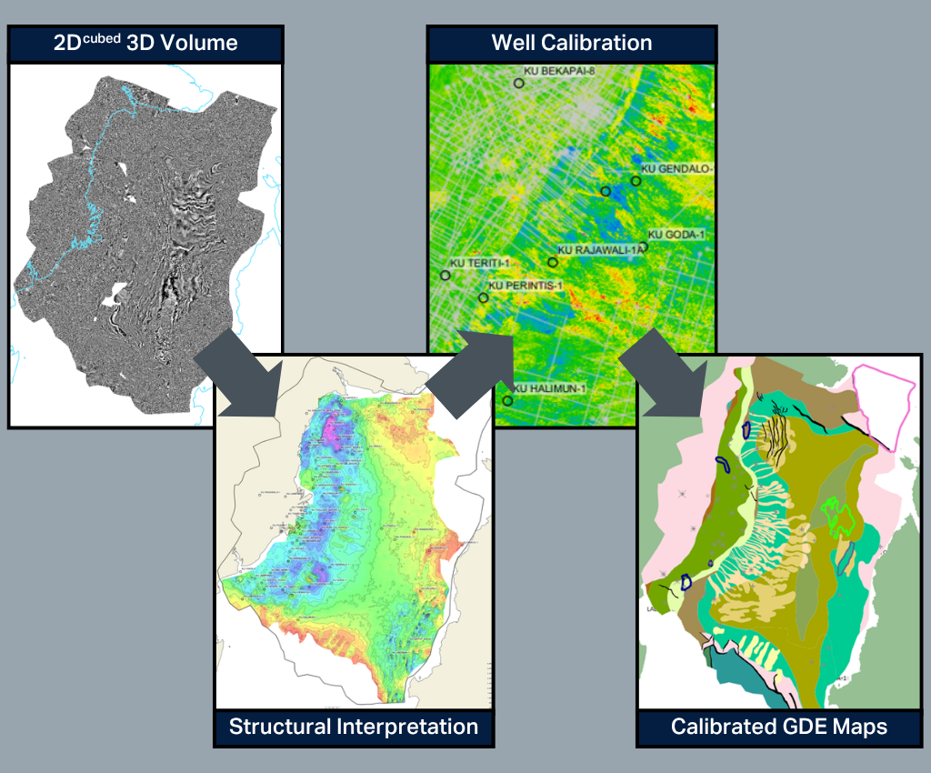
TGS applied its proprietary 2Dcubed technology to transform scattered, multi-vintage seismic into a continuous regional interpretation volume. The workflow used geological horizons derived from 2D dip fields and layered models to guide interpolation between seismic lines and bridge kilometer-scale data gaps. 2Dcubed is a structurally conformable interpolation engine that uses a six-step workflow, beginning with demigration to a common datum and global phase, amplitude, and time matching to create a unified 2D dataset. Dip and coherence attributes then guide geology-driven 3D interpolation that honors subsurface structure.
Alongside the standard products, TGS also offers tailored 2D post-stack processing, including advanced machine learning (ML) to enhance signal quality, suppress noise and improve stratigraphic resolution in legacy datasets. The 2D lines can also be reprocessed from raw gathers before 2Dcubed to further improve imaging, noise attenuation, bandwidth, and the final 3D volume.
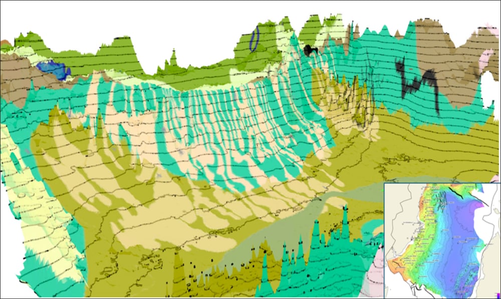
The 3D volume provided a consistent basis for mapping regional horizons, faults and mega-sequences. Interpretation was calibrated with 62 wells incorporating conditioned logs, lithology, biostratigraphy, sequence stratigraphy, facies and bathymetry. Together, these products supported structural mapping, depositional reconstruction and calibrated GDE mapping across key petroleum-system intervals.

The Results
Basin Evolution Revealed Through Time
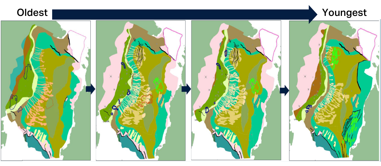
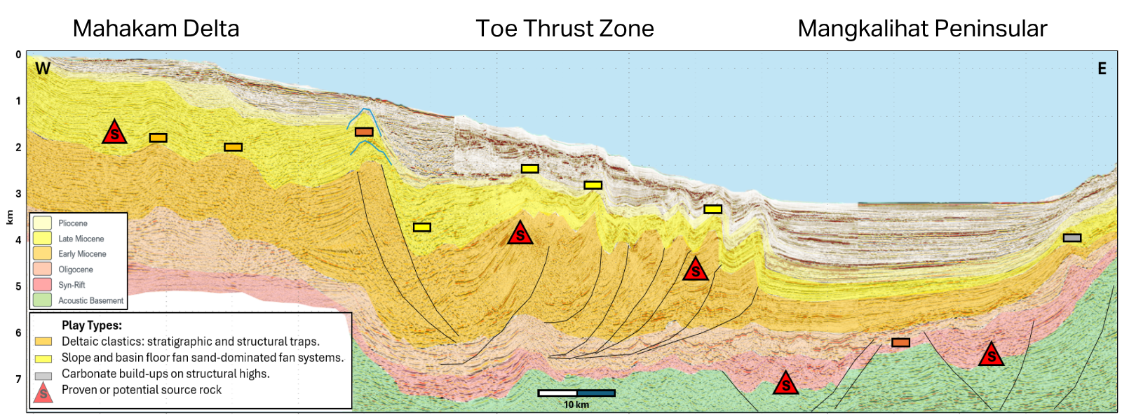
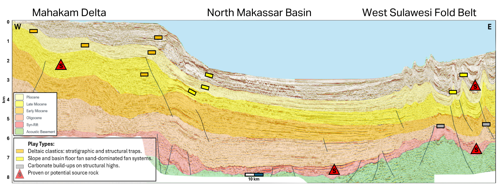
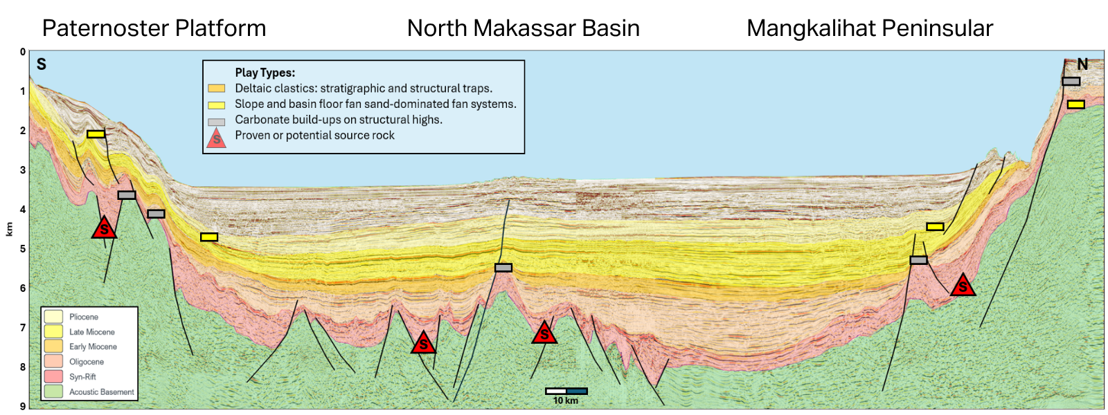
The integrated interpretation reconstructed depositional development from the Late Eocene to Early Pliocene. It identified the onset of Mahakam-derived sedimentation in the Early Miocene, major progradation from the Middle Miocene and increasingly extensive slope channels and basin-floor fans.
The study also improved understanding of carbonate development on structural highs, paleo-shelf-break evolution, and contourite bodies associated with repeated fault-zone reactivation along the southern project boundary.
A Continuous Basin-Scale Seismic Framework
The project transformed the multi-vintage 2D archive into one coherent regional volume. Interpreters could trace key mega-sequences across the project area, map large-scale structures and develop a consistent framework for well ties. The matched input lines, regional velocity field and 3D output also provided complementary products for subsequent evaluation.
Instead of navigating disconnected surveys line by line, exploration teams gained a continuous, interpretable view of the basin across areas of variable data density and historical exploration focus.
Consistent Calibration Beyond the Wells
Conditioning and interpreting the well database established consistent geological control for the basin-wide seismic interpretation. Lithology derived from cuttings, core descriptions, biostratigraphic reports and log responses supported chronostratigraphic, lithostratigraphic and sequence-stratigraphic picks. The well interpretations were tied to regional seismic horizons using calibrated time-depth pairs and synthetics. This integration strengthened correlations between wells and enabled depositional environments to be extended more consistently into sparsely drilled and undrilled parts of the project area.
Stronger Fairway and Prospect Definition
Regional structural and depositional mapping clarified the distribution of multiple play types. The interpretation highlighted deeper syn-rift structures, carbonate build-ups on structural highs, deltaic structural and stratigraphic traps, slope and basin-floor fan systems, contourites and lowstand sands extending into deeper water. Calibrated GDE maps strengthened fairway definition and helped identify potential prospects at several stratigraphic levels. The resulting regional perspective supports rapid screening of mature and underexplored areas, including time-sensitive evaluation of acreage before a licensing round closes.
Conclusion
The Kutei 2Dcubed project demonstrated how extensive legacy data can be transformed into a modern regional exploration asset. By combining 119 seismic vintages with detailed interpretation from 62 wells, the study established a coherent structural and stratigraphic framework and produced calibrated GDE maps across key intervals. The 2Dcubed volume enabled continuous mapping of depositional systems, structural trends and reservoir fairways across established and underexplored areas. The result is a basin-wide interpretation platform that supports exploration screening, secondary-play evaluation and further regional studies without depending exclusively on immediate new acquisition.
Commercial Impact

Extended the Value of Existing Seismic
Transformed scattered, multi-vintage 2D surveys into a continuous, interpretable regional volume.
Offered a Basin-Wide Perspective
Enhanced Exploration Efficiency
Improved Fairway Definition
Supported Prospect Identification