Extension of 3D survey by TGS will illuminate deeper zones for future development.
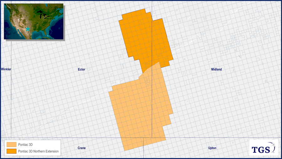
TGS announced an extension to Pontiac 3D last Monday, a new multi-client onshore seismic program in the Midland Basin. The northward extension straddles Ector and Midland Counties, increasing the original survey area from 167 mi2 to 267 mi2, and will provide operators with a new tool to evaluate deeper horizontal targets in the Barnett, Mississippi Lime, and Devonian. Already proven in nearby Andrews County, these deeper zones are envisioned to drive production growth as Wolfcamp and Spraberry production matures.
According to TGS Well Data Analytics, horizontal production across the Pontiac 3D area has been concentrated throughout the Wolfcamp and Spraberry formations. Total horizontal production peaked in 2019 at 3.7 MMBOE and 10.2 MMBOE, respectively, followed by a decline of 45% through 2022. Andrews County has shown a similar trend in the same formations with total horizontal production peaking in 2019 for the Wolfcamp and Spraberry at 15.4 and 9.0 MMBOE before declining by 42% through 2022. However, in recent years, Andrews County has witnessed growth from deeper zones in the Barnett, Mississippi Lime, and Devonian comprising 1.9 MMBOE or 21% of horizontal production in the county in 2022.
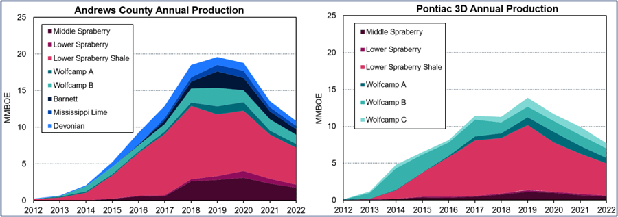
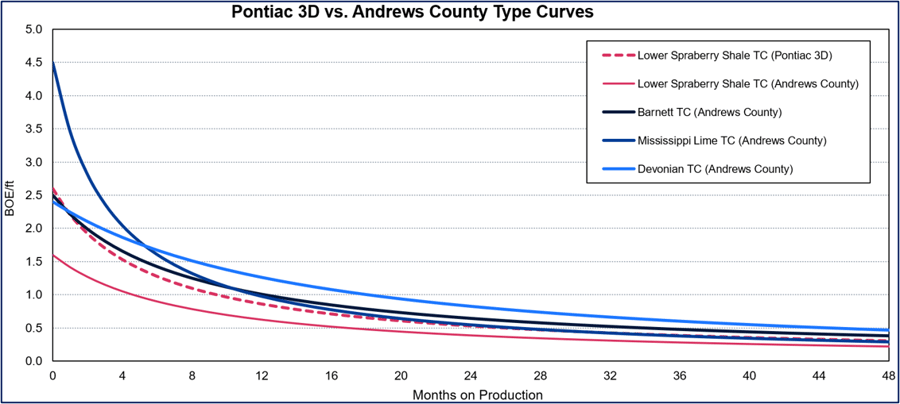
In Andrews County, productivity across the Barnett, Mississippi Lime, and Devonian is on par with that of the Lower Spraberry Shale interval, which contributed 56% of horizontal production in Pontiac 3D and 47% in Andrews County in 2022. Assessing peak rate of BOE per foot of lateral length in Andrews County, the Barnett leads at 4.5 BOE/ft followed by the Mississippi Lime at 2.5 BOE/ft, and Devonian at 2.4 BOE/ft. Notably, these are all higher compared to the Lower Spraberry Shale in Andrews County at 1.6 BOE/ft and Pontiac 3D at 2.6 BOE/ft. Over an economic life of 25 years, the type EURs per foot are also higher for the deeper zones with the Barnett at 80.2 BOE/ft, Mississippi Lime at 70.0 BOE/ft, and Devonian at 89.2 BOE/ft, compared to the Lower Spraberry Shale in Andrews County at 66.6 BOE/ft and Pontiac 3D at 46.2 BOE/ft. The Pontiac 3D survey will be a new tool to illuminate these deeper zones, potentially becoming a key driver of production growth across the area.
For more information on Well Data Analytics or to schedule a demo, contact us at WDPSales@tgs.com.