
Houston, Texas (7 November 2019) - TGS and WhiteStar™ announced today a partnership to jointly provide a robust solution combining TGS well data and WhiteStar land grid GIS data, coupled with field and pool data.
WhiteStar provides expert land grid GIS data and software land mapping solutions for the oil and gas industry, forestry, government, and others. This partnership allows for TGS to add WhiteStar products to its data offerings for clients who need access to land grid and cultural data. These insights will be fully integrated into TGS’ mapping applications, R360™ and LONGBOW™, for fast, easy access. Furthermore, WhiteStar will offer TGS’ Validated Well Header and Field & Pool GIS Data through its sales channels for customers who need additional location data to fully utilize the value of WhiteStar products.
Robert White, CEO of WhiteStar Corporation, said, “Customers will greatly benefit from a best-in-breed integration of our highly curated land data and the well-respected TGS field, pool, and validated well header data.”
Katja Akentieva, EVP Onshore and Well Data at TGS, said, “We are excited about our partnership with WhiteStar and believe it will allow our customers greater access to solutions-based land and well data - all in one place. Clients can now expect higher quality, cost-effective data solutions, with access to seamless grid coverage and accurate well locations.”
R360, a unique geoscience data portal, integrates TGS data libraries with existing technologies and applications. It allows customers to readily access the industry’s largest volume of high-integrity global geoscience data, including detailed well statistics and well performance information. In December, a significant user-guided upgrade to the R360 portal will be rolled out, with features including enhanced text and map search functions.
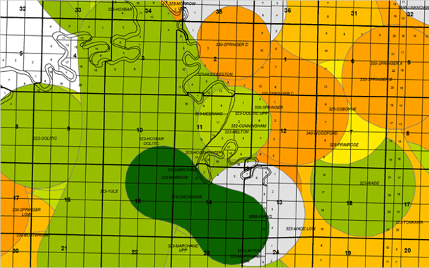
This graphic shows an overlay of WhiteStar Grid® (black and white land grid) with TGS field and pool data (colored polygons) to provide basic geographical context for oil and gas basemaps.
About WhiteStar
WhiteStar Corporation is a nimble company supplying software, web streamed data and services to quickly and efficiently map customer land holdings since 1990. WhiteStar’s flagship product, WhiteStar Grid® enables customers to map significantly more legal descriptions more quickly than any other solution.
For more information, visit WhiteStar at www.whitestar.com.
About TGS
TGS-NOPEC Geophysical Company (TGS) provides multi-client geoscience data to oil and gas Exploration and Production companies worldwide. In addition to extensive global geophysical and geological data libraries that include multi-client seismic data, magnetic and gravity data, digital well logs, production data and directional surveys, TGS also offers advanced processing and imaging services, interpretation products, and data integration solutions.
For more information, visit TGS online at www.tgs.com.
For additional information about this media release, please contact:
Jaclyn Townsend, Director, Brand Marketing, Tel: +1 832-667-4757, Email: jaclyn.townsend@tgs.com