


The Location
Location
Gulf of America, North America
Project
Amendment Ph1 & 2 Elastic FWI
Date Processed
2025
Data Type
3D Seismic
Survey Type
OBN
Survey Size
1,906 sq mi

The Challenge
Imaging Challenges Imposed by Massive Salt Structures
Thick, rugose salt canopies with overhangs, welds and feeders distort ray paths and create shadow zones. Legacy wide-azimuth streamer data lacked sufficient offsets to drive robust diving-wave inversions at depth. Resulting models suffered from velocity uncertainty, structural mispositioning and poor illumination of steep salt flanks, deep carbonate horizons and basement reflectivity. Interpretation risk remained high in key exploration fairways.

Acoustic Inversions Struggle in High-contrast Media
Acoustic-only FWI and top-down tomography have limitations on elastic media and can introduce cycle skipping and velocity leakage near strong impedance contrasts. Salt boundaries and inclusions may be mispositioned, halos can appear around salt and reflectivity continuity beneath salt is compromised. Conventional workflows require intensive interpreter intervention and extended cycle time, which delays project delivery and increases uncertainty.


The Solution
Acquisition Solution(s)
Sparse, long-offset ocean bottom nodes (OBN)
Pre-Processing Solution(s)
Broadband OBN processing
Velocity Model Building
FWI-based workflow
FWI Details
Elastic Dynamic Matching FWI (E-DMFWI) up to 24Hz
Imaging Solutions
RTM; FWI-Derived Reflectivity (FDR)
Acoustic-only FWI and top-down tomography have limitations on elastic media and can introduce cycle skipping and velocity leakage near strong impedance contrasts. Salt boundaries and inclusions may be mispositioned, halos can appear around salt and reflectivity continuity beneath salt is compromised. Conventional workflows require intensive interpreter intervention and extended cycle time, which delays project delivery and increases uncertainty.

The Results
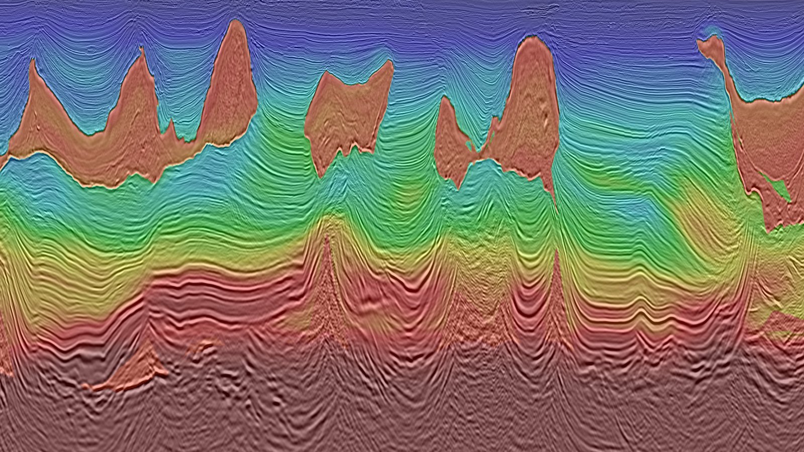
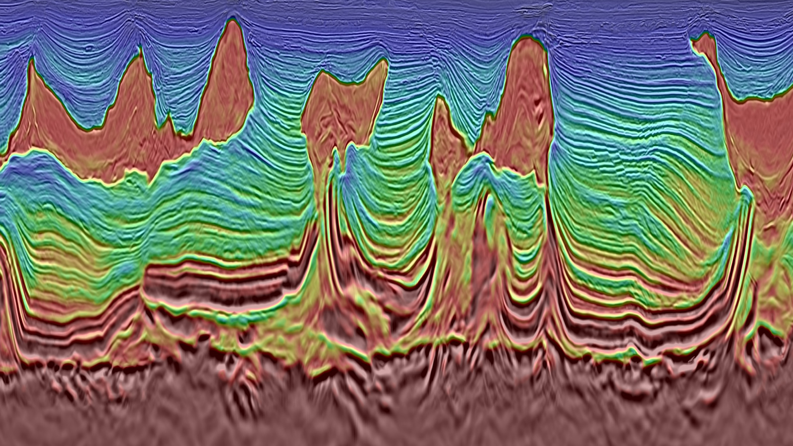
Sharper Salt Bodies and Feeders with Improved Depth Positioning
E‑DMFWI produces sharper, more accurate salt boundaries, mitigates salt-related artifacts and clarifies high-angle feeders and small inclusions. The updated velocity model improves salt exit velocities and increases illumination along steep flanks. The improvements translate into better depth positioning and reduced interpretation ambiguity compared to legacy WAZ RTM products and acoustic FWI alone.
Enhanced Continuity of Deep Reflectors and Basement Imaging
The E‑DMFWI velocity and FWI-derived reflectivity volumes improve continuity of deep carbonate horizons at the base of the Miocene and resolve basement reflectivity with greater confidence. The inversion-based reflectivity offers stratigraphic and structural detail that complement migration images, supporting more reliable play fairway mapping and prospect evaluation beneath complex salt.
Reduced Cycle Time and Uncertainty in Complex Sreas
The integrated acquisition and inversion strategy shortens the model-building cycle and reduces manual intervention. The combination of ultra-long offsets, broadband processing and elastic physics supports stable convergence and geologically conformable models from shallow to deep. The outcome is faster delivery of higher-confidence products that enable more decisive exploration planning in salt-influenced provinces.
Project Credits: TGS Multi-Client and Imaging & Technology teams, in collaboration with SLB.