Enhanced spatial sampling for high-quality seismic imaging

Expanding Possibilities with Multi-Source Acquisition

Wide-tow multi-source acquisition enables a more uniform near-offset distribution, improving the resolution and seismic image quality of shallow geology. By deploying multiple source arrays laterally, the system enhances the crossline spatial sampling of the emitted wavefield, especially valuable in areas where near-surface resolution is critical.

Advantages of Multi-Source Acquisition

tgs-check-25

Denser crossline spatial sampling enables higher frequency signals for high-resolution broadband imaging

tgs-check-25

Wider source spreads improve near-offset coverage without sacrificing acquisition efficiency

tgs-check-25

Compatible with eSeismic surveys for reduced acoustic footprint in sensitive marine environments

Optimizing Imaging with Improved Near-Offset Distribution

TGS can tow up to six independent source sub-arrays in a range of configurations. These can be arranged in a traditional lateral spread, between the innermost streamers, or deployed in wide-tow mode with significantly larger lateral separation. Both approaches enhance the spatial sampling density of CMP (common midpoint) sublines and increase the high-frequency content of migrated seismic images.

An important variation of this method is eSeismic, a low-footprint acquisition concept where individual air guns are randomly triggered several times per second. These can be arranged in traditional or wide-tow formats. eSeismic produces the lowest acoustic output of any known source configuration and is well suited for surveys in environmentally sensitive areas.

In the example illustrated below, near-offset coverage is compared between a standard quad-source and a wide-tow quad-source setup. Both configurations use identical streamer layouts (10 streamers at 50 m spacing, with 250 m sail-line separation). While standard quad sources concentrate near offsets around the sail-line, wide-tow configurations result in more uniform near-offset trace distribution across the crossline. This enhanced coverage creates a stronger starting point for regularization and interpolation workflows, improving near-surface imaging. Near-offset sampling strategies are tailored to the specific imaging objectives, water depth, and complexity of the shallow geology.

Multi-source solutions - Fig1
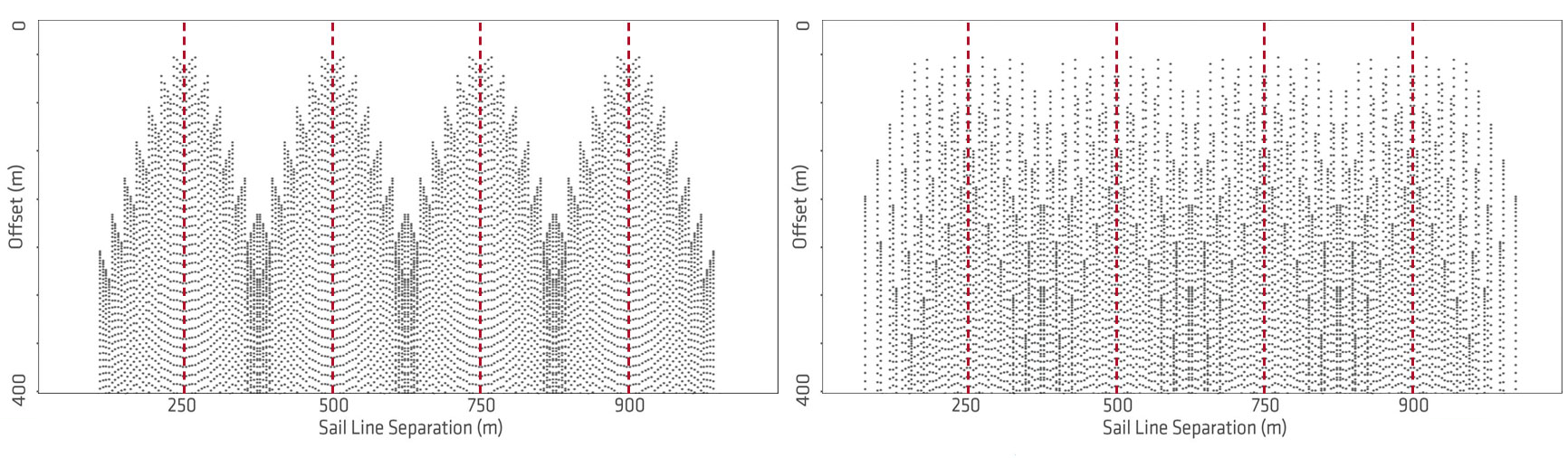
High-density streamer configurations of 10 streamers with 50 m separation combined with a standard quad-source set-up (left) and a wide-tow quad-source set-up (right). The wide-tow source separation is 62.5 m, resulting in a total source spread with of 187.5 m. The corresponding near-offset distributions are shown on the right. CMP-X positions are along the x-axis, and source-receiver offsets are along the y-axis. The red dashed lines indicate the center of each sail line. The wide-tow source configuration provides a significantly improved and uniform near-offset coverage.

Tailored Geometries for Advanced Applications

Wide-tow multi-source configurations are a key component of GeoStreamer X surveys, which combine large sensor spreads, long streamers, and optimized source placement to improve both deep and shallow imaging. This approach supports accurate Full Waveform Inversion (FWI) and helps reduce artifacts commonly introduced by traditional acquisition geometries.

The example shown on this page demonstrates the impact of enhanced near-offset coverage in a challenging geological setting. This area includes glacial channels, shallow gas accumulations, and rugose chalk layers, all of which typically degrade seismic image quality. With improved spatial sampling and near-offset distribution, the new dataset resolves these features with greater clarity, continuity, and resolution.

Multi-source solutions - Fig2
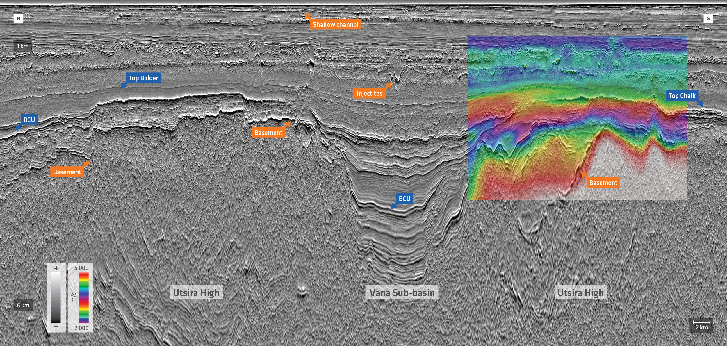
South Viking Graben example of GeoStreamer X data where wide-tow multi-source shooting has contributed to high-resolution imaging of various stratigraphic features at all depths of interest. The color overlay is part of the high-resolution velocity model.

The same wide-tow multi-source principles can be applied to near-surface 3D studies, including:

  • Carbon Capture and Storage (CCS) site characterization
  • Marine mineral exploration
  • Offshore wind farm siting

In such cases, recording seismic data at close-to-zero offset is often essential. This can be achieved by moving source arrays over the front of the streamer spread, minimizing inline offset and improving resolution in the very shallow section. When paired with multisensor GeoStreamer data, the result is seamless broadband imaging, from seabed to deeper targets, with fewer acquisition-related artifacts.

Let’s Discuss Your Acquisition Needs

With the industry’s most diverse fleet and integrated expertise, from survey design and acquisition to seismic data imaging, TGS delivers trusted, tailored solutions for complex exploration challenges.

Learn More About Our Fleet

Discover the capabilities, configurations and proven performance of our diverse fleet. Built for reliability and efficiency, our vessels are ready to meet your exploration needs, anywhere in the world.

Start the Conversation

Every project is different. Talk to a TGS expert about your specific acquisition requirements. With decades of trusted experience and integrated capabilities, we’ll help you design the right solution from the start.