Barnett and Woodford formations show growing potential as Tier 1 Wolfcamp and Bone Spring inventories decline.
As open Tier 1 acreage in the Bone Spring and Wolfcamp formations become increasingly limited, operators across the Permian Basin are re-evaluating their development strategies. Traditional landing zones, while historically prolific, produce higher water volumes and exhibit rising water-oil ratios as inventories mature.
Leveraging TGS Well Data, our analysis of primary Permian Basin targets from 2005 to 2025 reveals a 120% increase in water-oil ratio, highlighted in Figure 1, underscoring the growing challenge of water management in mature zones.
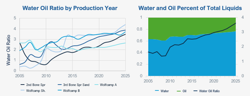
Figure 1. Primary unconventional targets in the Permian Basin are showing increasing water production over time.
In contrast, formations such as the Barnett and Woodford present compelling alternatives. Figure 2 illustrates that these zones demonstrate oil performance comparable to the primary producing targets within the Permian Basin. While historically viewed as less productive, Barnett and Woodford generate significantly less water and show promising economic potential, particularly as existing infrastructure across the Midland Basin supports efficient development and reduced operating costs.
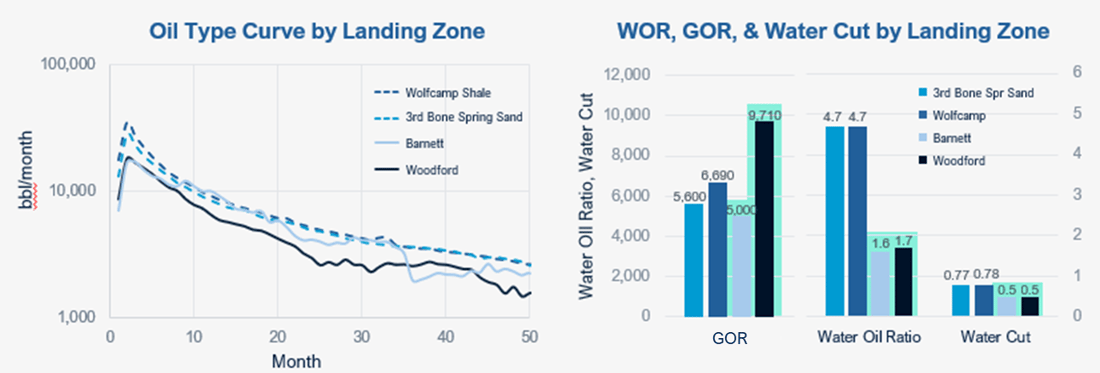
Figure 2. Barnett and Woodford formations produce significantly less water while delivering oil performance comparable to primary Permian Basin targets.
The Barnett Shale is located along the complex margin between the Central Basin Platform and Midland Basin. To accurately steer and land horizontal wells targeting the Barnett, a high-resolution understanding of the structural geology is essential, and 3D seismic data plays a critical role. To support these efforts, TGS has been actively conducting extensive 3D seismic surveys in the region. TGS purchased the Block 1 3D seismic survey in 2019, covering 51 square miles in Andrews County. In early 2023, TGS also launched the Pontiac 3D seismic survey, spanning 167 square miles across Ector, Crane, Midland, and Upton counties. Later that year, the survey was extended further into Ector and Midland counties, increasing its coverage to 267 square miles. These seismic surveys provide operators with enhanced visibility into deeper hydrocarbon accumulations in the Barnett, Mississippian, and Devonian formations. Insights from the Block 1 and Pontiac 3D surveys have already led to profitable Barnett wells with lower water cut and higher production type curves (Figure 3), and future production growth is expected as more wells are drilled in these formations.
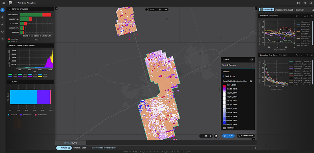
Figure 3. The TGS Well Data Analytics application showing active producing wells in the Block 1 and Pontiac 3D surveys, color-coded by first production month and their water cut (top) & daily oil production (bottom) type curves .
With strong net pay observed in the core areas and improving development potential, Barnett, and, to a lesser extent the Woodford, are emerging as viable next-generation targets for sustained production and long-term basin optimization.
The latest TGS Basin Insight: Permian Deep Exploration report and TGS Basin Insight: Permian Deep Exploration article offer a comprehensive analysis of the region, diving into geology, economics, and well performance. To explore TGS available well data or schedule a demo, contact us at WDPSales@tgs.com.