


The Location
Location
Pará-Maranhão Basin, offshore Brazil
Survey
PAMA 3D Phase I and Phase II
Survey Year
2024-2026
Data acquisition (in this study)
Narrow-Azimuth (NAZ) Towed Streamer
Data Deliverables
TTI PSDM Gathers/Stacks/Velocities
Survey Size
~19,400 sq. km (Phase I); ~11,500 sq. km (Phase II)
Total Permitted Area
~55,000 sq. km

The Challenge
Imaging a Complex Frontier Basin
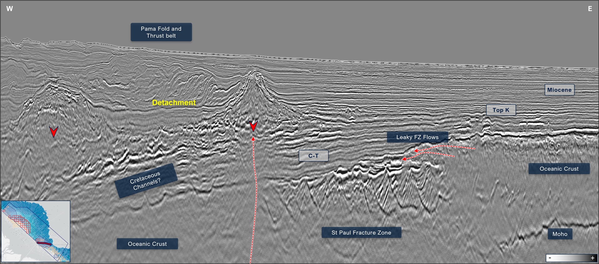
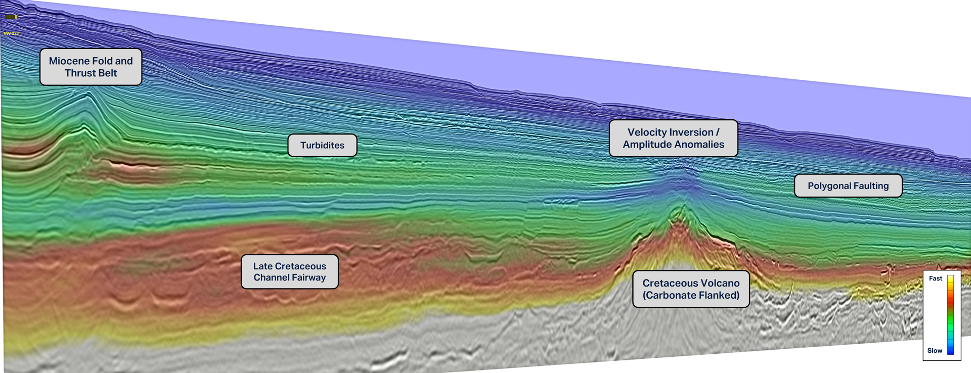
The Equatorial Margin contains complex depositional systems including deepwater fans and stratigraphic pinch-outs, combined with localized volcanic sequences and structurally complex fold-and-thrust zones. These features can distort seismic wave propagation and complicate velocity model building, requiring advanced acquisition and imaging workflows to deliver reliable subsurface images. Operationally, strong ocean currents can cause significant variations in vessel speeds, directly affecting shot overlap and the effectiveness of the deblending process.
Limited Regional Subsurface Context
Frontier basins often lack well control and seismic coverage, making regional seismic surveys essential for understanding basin structure and petroleum systems. Despite growing interest in the Equatorial Margin, the Pará-Maranhão Basin remains underexplored with insufficient seismic data to reveal large-scale plays. Operators require basin-scale seismic data to evaluate sediment pathways, structural trends and stratigraphic relationships across blocks. Without this, it is challenging to assess prospectivity, compare plays, or prioritize exploration targets confidently.
Managing a Program at Scale
PAMA 3D ranks among the world’s largest multi-client seismic programs, covering a permitted area of over 55,000 sq. km. Programs of this scale typically involve multiple service providers throughout the project lifecycle: permitting, acquisition, processing and commercialization.Industry research shows that geoscientists spend over 60% of their productive time managing seismic data(1) between systems, while fragmented operating models can leave more than $5 per barrel of oil equivalent (BOE) in unrealized value(2).
- AWS for Industries, Accelerate the Seismic Data Workflow, 2021
- McKinsey & Co, Harnessing volatility: Technology Transformation in Oil and Gas, 2022
Delivery Ahead of License Rounds
The PAMA 3D program includes blocks under study for 2026-2027 licensing rounds. Exploration teams require sufficient time to interpret regional data, identify play concepts, mature prospects, perform risk assessments and evaluate their bidding strategy before submitting bids. Any delay in acquisition, processing, or data delivery reduces the time available for technical analysis and can directly impact operators’ ability to assess risk and prepare competitive bids.


The Solution
Acquisition Design
- T-Class Ramform Vessels
- GeoStreamer multisensor technology
Pre-Processing Solution(s)
Modern broadband processing, including:
- Machine learning denoise
- FISTA inversion-based deblending
- 4D regularization and interpolation
VMB and Imaging
- Dynamic Matching FWI
- TTI LS-KPSDM and RTM
Commercial Model
- Multi-Client, with industry support
Data Management
- Imaging AnyWare® platform
- Vessel-to-shore LEO satellite data transfer and continuous QC
The unique integrated business model provided by TGS enabled the seamless end-to-end management of the PAMA 3D project from survey planning through final commercialization. The company deployed Ramforms Atlas and Titan, both Titan-class seismic vessels, equipped with GeoStreamer® multi-sensor technology. Cloud-based data management and a digital data library infrastructure, with periodic data transfers via LEO satellites, reduced friction between the offshore and onshore processing teams.
The in-house imaging teams regularly communicated with the operations geophysicists on the vessels to maintain control over quality and schedule. Satellite transmission of data, Machine Learning (ML) workflows and Dynamic Matching Full Waveform Inversion (DM FWI) were leveraged to accelerate processing and imaging, maintaining data integrity. Continuous feedback between operational execution, technology teams and commercial planning was central to the integrated model.


The Results
.png)
Earlier Insight for Licensing
While projects of this scale often involve multiple service providers across permitting, acquisition, processing and commercialization, TGS integrates acquisition, imaging and data delivery into an end-to-end workflow across the project lifecycle. This approach eliminates the operational inefficiencies associated with large seismic programs by minimizing data transfers, limiting repeated quality-control cycles and improving collaboration. The result is faster delivery of exploration-ready datasets through TGS’ Data Library and digital platform, allowing exploration teams to begin interpretation earlier and extend the time available for prospect evaluation ahead of upcoming licensing rounds.
Regional Exploration Context
The PAMA program provides basin-scale seismic coverage that supports regional geological analysis across the Equatorial Margin. Phase I delivers 19,343 sq. km of new 3D data, while Phase II expands coverage by approximately 11,500 sq. km. By combining TGS’ Multi-Client Data Library and data management infrastructure, the survey becomes part of a broader regional dataset that supports basin-wide interpretation. The scale of coverage allowed operators to evaluate structural trends, sediment pathways and petroleum system elements across multiple blocks rather than in isolation, strengthening exploration planning in Brazil’s Equatorial Margin.
Conclusion
The PAMA 3D program illustrates how integrated seismic execution can accelerate exploration in frontier basins. By combining basin-scale coverage, advanced imaging technologies and digital delivery platforms, TGS provides operators with earlier access to high-quality subsurface data, enabling faster prospect evaluation and more informed participation in upcoming licensing rounds across Brazil’s Equatorial Margin.
Commercial impact
Extensive Seismic Coverage
More than 30,000 sq. km of broadband 3D seismic across Phase I and Phase II.