


The Location
Location
Western Mississippi Canyon, Gulf of America
Survey
Amendment FAN 3D Phase 4
Survey Year
2025 – 2026
Data acquisition (in this study)
Long-Offset Sparse OBN
Data Deliverables
Velocity Models, FDR and RTM
Survey Size
~1,142 sq.km
Water depth
~100 m – 850 m

The Challenge
Resolving Complex Salt Architecture
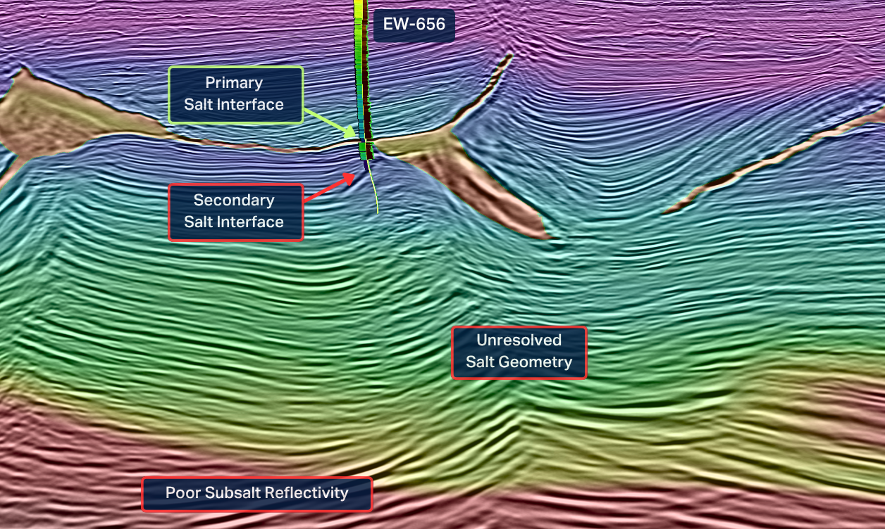
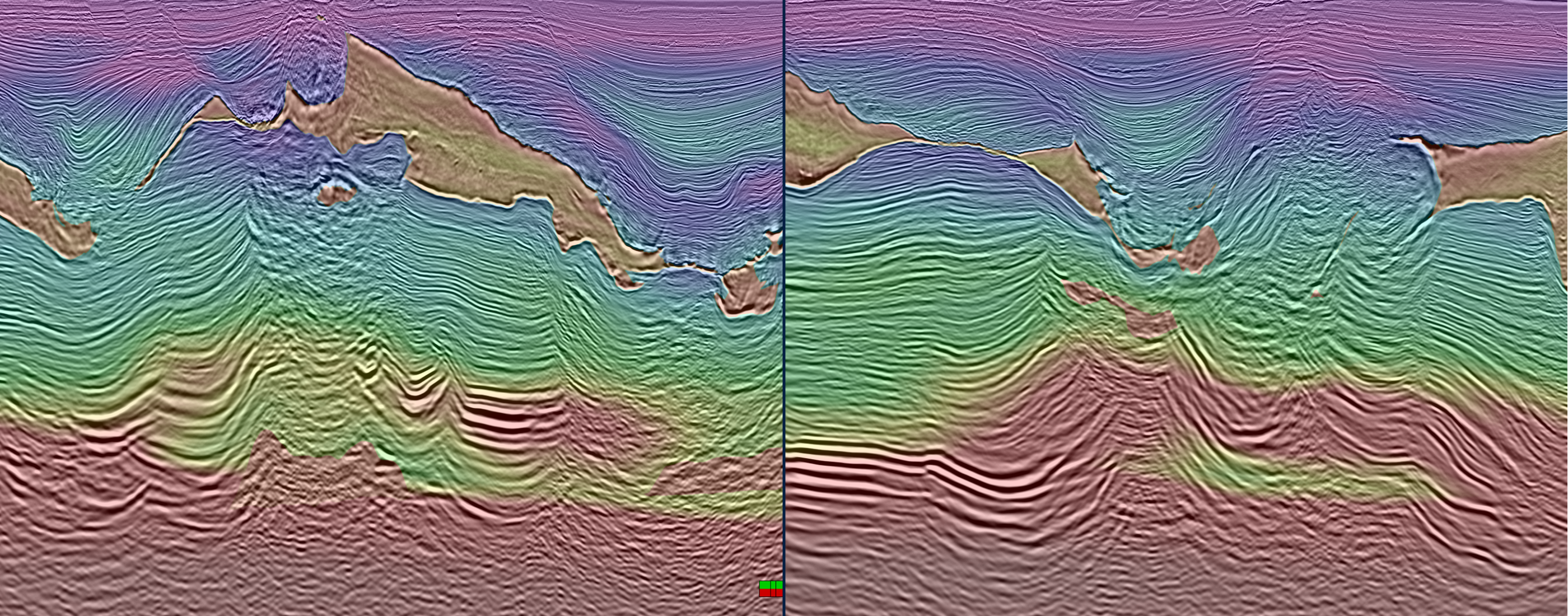
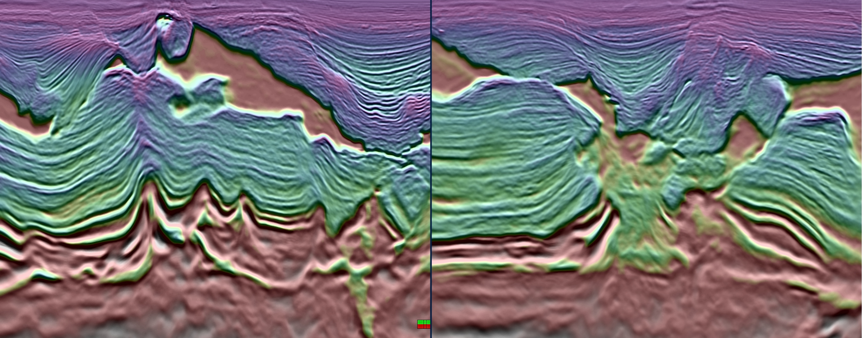
Legacy wide-azimuth (WAZ / M-WAZ) surveys failed to accurately image the deep salt architecture beneath the Mississippi Canyon canopy system. In several areas, seismic continuity deteriorated significantly below salt, leading to uncertainty in trap definition and reservoir interpretation.
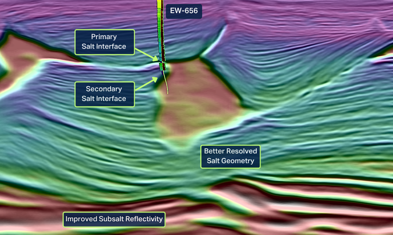
As an example, the Jedd well (EW 656) highlighted these limitations after encountering an unexpected secondary salt body that was not predicted by previous velocity models. Existing datasets lacked the low-frequency content, offset distribution and azimuthal coverage required to properly resolve the salt geometry.

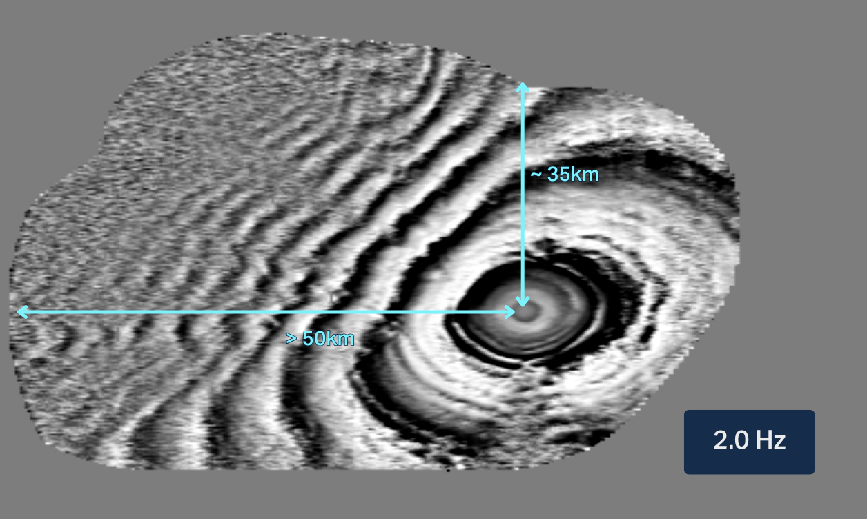
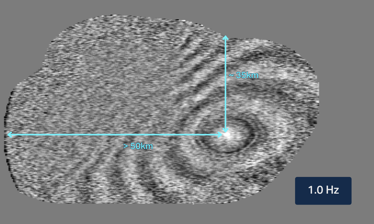
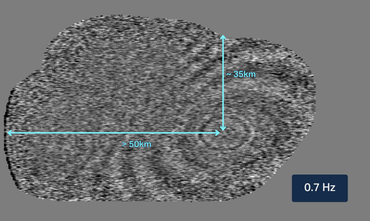
Better Ultra-Low Frequencies
Accurate FWI-driven velocity model building in complex salt environments relies on stable ultra-low-frequency signal content and long-offset full-azimuth coverage.
Conventional marine source arrays often struggle to provide coherent energy at the required frequencies to improve deep subsalt velocity updates. At the same time, sparse OBN acquisition geometries require designs capable of maximizing offset and azimuth coverage while preserving shot density and signal quality for imaging and inversion.
Maximizing Exploration OBN Efficiency
Large-scale exploration OBN programs in the Gulf of America involve substantial operational complexity and higher acquisition costs compared to streamer surveys. Maintaining efficient production while introducing new source technologies can be difficult, particularly when lower-frequency sources require longer refill times.
A scalable acquisition strategy that improves operational efficiency without compromising data quality, shot density or imaging performance was needed.


The Solution
Acquisition Design
- Gemini Enhanced Frequency Source
- Dual vessel, quad-tow configuration
- Sparse ZXPLRe node grid
Pre-Processing Solution(s)
- OBN tailored processing
- FISTA inversion-based deblending
VMB and Imaging
- Elastic Dynamic Matching FWI
- RTM and FDR Imaging
Data Management
- Vessel-to-shore LEO satellite data transfer
- Imaging AnyWare® processing platform
- Remote center operations
TGS implemented an industry-first integrated acquisition and imaging workflow combining Gemini Enhanced Frequency Source technology, ultra-long offset sparse OBN acquisition and Elastic Dynamic Matching FWI (E-DMFWI). The acquisition utilized two source vessels, each equipped with four Gemini EFS (quad-tow), together with a sparse ZXPLRe node grid optimized for full-azimuth long-offset illumination.
Long dithering windows and TGS’ FISTA-based deblending workflow preserved shot density while supporting simultaneous source operations. The acquired dataset was processed using an advanced OBN pre-processing toolkit and an E-DMFWI-based imaging workflow to improve salt definition and subsalt image continuity.

The Results

Stable Low-Frequency FWI Performance
Gemini delivered coherent low-frequency signal content down to sub-Hertz frequencies while maintaining full-azimuth illumination. The combination of low frequencies, long offsets and E-DMFWI improved model stability and reduced dependence on heavily interpreted starting models. The enhanced dataset produced improved continuity across subsalt reflectors and delivered more reliable velocity updates in complex salt environments.
Improved Regional Interpretation
The data-driven E-DMFWI workflow successfully captured previously unresolved salt geometry and unidentified subsalt features not visible on legacy datasets without the need of manual interpretation. In the Jedd well location, Amendment 4 E-DMFWI results accurately imaged the secondary salt body encountered during drilling, significantly improving geological understanding of the subsalt system. The updated velocity model revealed a salt feeder connecting the shallow canopy to deeper Louann salt, providing improved structural continuity and reducing uncertainty in trap definition and regional interpretation.
Conclusion
This case study showcases an industry-first unified solution for complex subsalt imaging by integrating Gemini EFS technology, ultra-long offset sparse OBN acquisition and E-DMFWI into a single exploration workflow. The program improved subsalt illumination, stabilized velocity model building and increased imaging confidence in one of the Gulf of America’s most challenging geological settings. At the same time, TGS advanced operational efficiency through dual-vessel quad-tow Gemini acquisition while maintaining the data quality required for high-end imaging and inversion.
The technologies and workflows proven on Amendment 4 establish a scalable foundation for future exploration programs across complex salt basins in the Gulf of America, South Atlantic and Mediterranean regions.
Commercial impact
Reduced Exploration Risk
Improved subsalt imaging and more reliable velocity models help reduce uncertainty in prospect evaluation, trap definition and well planning.